1900s (20th Century) Maps of Cable, Wisconsin
Explore 9 historic maps of Cable from the 1900s (20th Century). These maps offer a rare glimpse into what life looked like during the 1900s — showing old roads, neighborhoods, homes, and landmarks that have changed or disappeared over time.
Whether you're researching your family's past, planning a metal detecting trip, or studying how Cable's landscape evolved across the 1900s, these high-resolution maps are a powerful tool for exploring the history of this region.
- Focus on a specific era: All maps on this page are from the 1900s, giving you a focused view of this time period.
- See what’s changed: Compare century-old streets, trails, and buildings to today's modern landscape using overlays and satellite layers.
- Research with precision: Use these maps for genealogy, historical research, land use analysis, or educational projects.
- View, download, or print: Maps are fully viewable online in high resolution, and can be downloaded or printed for your own records.
Start exploring Cable's history through authentic maps from the 1900s. This is your window into the past.
Cable, WI maps
(9)- 1943 Map of Namekagon Lake, 1960 Print
 1943 Namekagon Lake1960 Print · USGSUpper Wisconsin’s lake country is captured here during the mid-1940s, showing a landscape of glacial waters and early forest infrastructure. Researchers can locate remote schools and camps like Spider Lake Sch and the Sawyer CCC Camp or trace the early shoreline of Lost Land Lake.2 unique versions available
 - 1944 Map of Hayward, 1965 Print
 1944 Hayward1965 Print · USGSHayward and the northern Wisconsin lake country are captured here at the close of the Second World War. Researchers can trace the Chicago St Paul Minneapolis and Omaha rail line to find vanished schoolhouses like Sabin Sch and the Indian Sch.
 - 1945 Map of Namekagon Lake
 1945 Namekagon Lake1945 Print · USGSThe National Forest of northern Wisconsin is shown here in the mid-1940s as a landscape of timber trails and remote camps. Researchers can locate the Sawyer CCC Camp, the Lost Land Lake Club, and local landmarks like the West Fork Fire Tower.2 unique versions available
 - 1953 Map of Ashland, 1964 Print
 1953 Ashland1964 Print · USGSNorthern Wisconsin's lakefront and timberlands are seen here in the mid-1950s, showing the intersection of industrial rail lines and vast wilderness. Genealogists and historians can trace the Soo Line through rail towns like Mellen or locate family roots in the Apostle Islands and Bad River Indian Reservation.3 unique versions available
 - 1958 Map of Ashland
 1958 Ashland1958 Print · USGSCoastal Wisconsin and the Michigan borderlands meet here in the late fifties, dominated by the timbered expanses and iron-rich ranges. Genealogists can trace family footprints in settlements like Odanah and Montreal, or locate landmarks such as the Coast Guard Station and Agricultural Experiment Station.
 - 1971 Map of Cable, 1973 Print
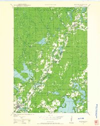
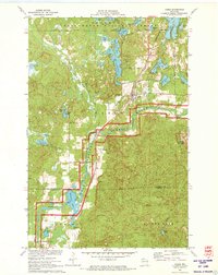 1971 Cable1973 Print · USGSBayfield County in the early seventies shows a landscape of deep forests and glacial lakes at the height of its mid-century recreational growth. Genealogists and local historians can trace the residents of Cable and Seeley or locate ancestral plots at St Anne Cem and Greenwood Cem.2 unique versions available
 - 1971 Map of Totagatic Lake, 1973 Print
 1971 Totagatic Lake1973 Print · USGSBayfield and Sawyer counties are captured here in the early seventies, a landscape of protected wetlands and thick forest at the edge of the Northwoods. Researchers can trace the courses of Hills Mill Creek and the Totagatic River or locate landmarks like the Smoky Hill Lookout Tower.2 unique versions available
 - 1971 Map of Lake Tahkodah, 1973 Print
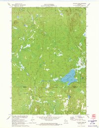
 1971 Lake Tahkodah1973 Print · USGSThe Northwoods of Bayfield and Sawyer counties are captured here in the early seventies, dominated by the Namekagon River. You can trace the development of recreation at Mount Telemark or locate remote camps on Star Lake and Lake Tahkodah.
 - 1980 Map of Solon Springs
 1980 Solon Springs1980 Print · USGSNorthern Wisconsin in the early eighties was a landscape of dense timber and sprawling glacial waters. Trace the legacy of the Chicago and North Western rail line through Solon Springs, Hayward, and Minong at this pivotal moment.
End of results
Showing maps 1-9 of 9
Top cities near Cable
Top neighborhoods of Cable
Frequently asked questions
- What are the different types of historical maps available for Cable?
- What is the oldest map of Cable?
- Where can I purchase historical maps of Cable for my home or office?
- Where can I download high-res historical maps of Cable?
- Are there historical topographic maps available for Cable?
- Is there historical aerial imagery available for Cable?
- Where are historical maps of Cable sourced from?