Old Maps of Herbster, Clover for Academic Research
Study the evolution of Herbster with 8 high-resolution historic maps. Whether you're teaching, researching, or modeling changes in land use, these maps provide essential visual documentation of urban, environmental, and geographic change.
- Analyze long-term change: Track patterns in development, transportation, and natural features.
- Ideal for environmental or urban studies: Support academic projects with primary historical map data.
- Use in the classroom or lab: Educators and researchers rely on these maps to bring historical context to life.
These maps are a powerful tool for teaching, research, and visualizing how Herbster has changed over the decades.
Herbster, Clover maps
(8)- 1943 Map of Port Wing, 1952 Print
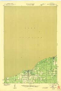
 1943 Port Wing1952 Print · USGSThe southern shore of Lake Superior comes into focus during the early 1940s, highlighting the coastal life and interior woodlands of Bayfield County. Researchers can trace the development of Port Wing and Herbster or locate family sites near Greenwood Cem and the Flag River.
 - 1946 Map of Port Wing
 1946 Port Wing1946 Print · USGSThe Bayfield County coast along Lake Superior is captured in the mid-1940s just as early highway and utility networks were expanding. Researchers can locate family sites near Port Wing and Herbster, or trace old forest trails like T Tr 181L and the Greenwood Cem.
 - 1953 Map of Ashland, 1964 Print
 1953 Ashland1964 Print · USGSNorthern Wisconsin's lakefront and timberlands are seen here in the mid-1950s, showing the intersection of industrial rail lines and vast wilderness. Genealogists and historians can trace the Soo Line through rail towns like Mellen or locate family roots in the Apostle Islands and Bad River Indian Reservation.3 unique versions available
 - 1958 Map of Ashland
 1958 Ashland1958 Print · USGSCoastal Wisconsin and the Michigan borderlands meet here in the late fifties, dominated by the timbered expanses and iron-rich ranges. Genealogists can trace family footprints in settlements like Odanah and Montreal, or locate landmarks such as the Coast Guard Station and Agricultural Experiment Station.
 - 1961 Map of Port Wing, 1963 Print
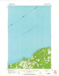 1961 Port Wing1963 Print · USGSThe South Shore of Lake Superior comes into focus in the early sixties, highlighting the coastal life of Bayfield County. Researchers can trace the development of Port Wing and Herbster or locate family sites near Greenwood Cem.2 unique versions available
 - 1980 Map of Port Wing
 1980 Port Wing1980 Print · USGSThe Lake Superior shoreline and the deep forests of Bayfield and Douglas counties are captured here in the early eighties. Genealogists and historians can trace the rail lines through Iron River or locate the lakeside landings at Cornucopia and Port Wing.
 - 1984 Map of Herbster
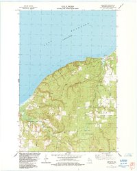 1984 Herbster1984 Print · USGSThe Lake Superior shoreline near Herbster comes into focus in the mid-1980s, showcasing a landscape of state-managed fishery and wildlife areas. Researchers can trace family-named routes like Matthews Road and Lenawee Road through the Clover township.
 - 2022 Map of Herbster, 2022 Print
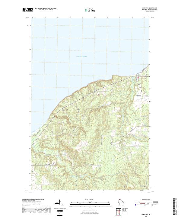 2022 Herbster2022 Print · USGSThe Bayfield County coast comes alive in this contemporary survey of the wooded shoreline and river valleys. Researchers can trace family-named landmarks and historical routes like Old School Rd, Beeksma Rd, and the paths of the Flag River.
End of results
Showing maps 1-8 of 8
Top cities near Herbster
Frequently asked questions
- What are the different types of historical maps available for Herbster?
- What is the oldest map of Herbster?
- Where can I purchase historical maps of Herbster for my home or office?
- Where can I download high-res historical maps of Herbster?
- Are there historical topographic maps available for Herbster?
- Is there historical aerial imagery available for Herbster?
- Where are historical maps of Herbster sourced from?