Old Maps of Delta, Wisconsin for Metal Detecting
Plan your next treasure hunt with 34 historic maps of Delta. Find old homesites, ghost towns, trails, and gathering spots that may be lost to time — perfect for identifying promising metal detecting locations.
- Locate forgotten sites: Uncover places like long-lost settlements, abandoned rail lines, or gathering spots.
- Plan better hunts: Use map overlays combined with LiDAR or satellite views to narrow in on historically rich areas.
- Made for detectorists: Thousands of hobbyists use these maps to discover relics, coins, and hidden history.
Use these historic maps to boost your research and find new opportunities beneath the surface of Delta.
Delta, WI maps
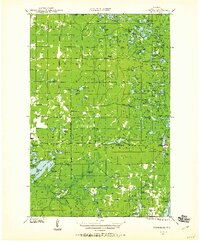
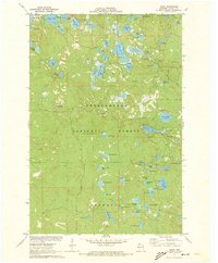
(34)- 1943 Map of Iron Lake, 1952 Print
 1943 Iron Lake1952 Print · USGSBayfield County at the height of the 1940s reveals a landscape of lakeside settlements and rural school districts centered around Iron River. Genealogists and local researchers can trace early homesteads and landmarks like Hillside Cem, Washington Sch, and the Iron River Fire Tower.
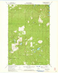
 - 1944 Map of Moquah, 1952 Print
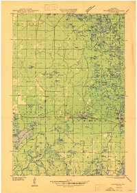
 1944 Moquah1952 Print · USGSBayfield County at the end of the Second World War shows a landscape of timber-town history and rural school districts. Genealogists and historians can trace the foundations of Moquah, locate family-named schoolhouses like Gednota Sch, and follow the long-vanished Old Grade logging routes.2 unique versions available
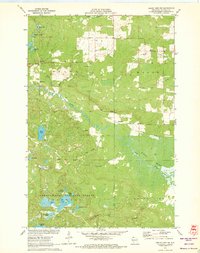
 - 1944 Map of Drummond, 1959 Print
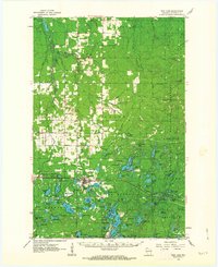
 1944 Drummond1959 Print · USGSBayfield County’s forest and lake country is captured here in the mid-forties, centered on the mill town of Drummond. Genealogists and researchers can locate rural landmarks like Hall Sch, the Old Chippewa Camp Ground, and a legacy CCC Camp.2 unique versions available
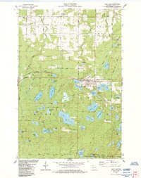
 - 1944 Map of Grandview, 1962 Print
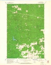
 1944 Grandview1962 Print · USGSBayfield County's Northwoods landscape is captured here during the mid-forties, showing the intricate network of rails and rural schools. Genealogists and historians can locate the Taylor Lake CCC Camp and trace family roots near Becker Sch, Grandview, and Mason.
 - 1947 Map of Drummond
 1947 Drummond1947 Print · USGSBayfield County's timber and lake country comes into focus in the years following World War II. Researchers can locate remote schoolhouses like Hall Sch and Barnes Sch. or trace the footprint of the Delta CCC Camp (Abandoned).2 unique versions available
 - 1947 Map of Moquah
 1947 Moquah1947 Print · USGSBayfield County in the late 1940s reveals a landscape of rural schoolhouses and forest management hubs like the Brinks Ranger Sta. Genealogists and historians can trace family locations near Hillsdale Sch, Gednota Sch, and the rail stop at Ino Sta.
 - 1947 Map of Iron Lake
 1947 Iron Lake1947 Print · USGSBayfield County at the end of the 1940s reveals a landscape of lakeside settlements and rural school districts linked by the Northern Pacific line. Researchers can trace local genealogy at Hillside Cem or locate former community sites like Kolin and Miles Sch.
 - 1947 Map of Grandview
 1947 Grandview1947 Print · USGSBayfield County at the close of the 1940s reveals a landscape of timber-towns and marshlands connected by the Chicago St Paul Minneapolis and Omaha rail line. Researchers can locate remote rural schoolhouses like Becker Sch and Dybedal Sch, or trace the winding course of the White River.
 - 1953 Map of Ashland, 1964 Print
 1953 Ashland1964 Print · USGSNorthern Wisconsin's lakefront and timberlands are seen here in the mid-1950s, showing the intersection of industrial rail lines and vast wilderness. Genealogists and historians can trace the Soo Line through rail towns like Mellen or locate family roots in the Apostle Islands and Bad River Indian Reservation.3 unique versions available
 - 1958 Map of Ashland
 1958 Ashland1958 Print · USGSCoastal Wisconsin and the Michigan borderlands meet here in the late fifties, dominated by the timbered expanses and iron-rich ranges. Genealogists can trace family footprints in settlements like Odanah and Montreal, or locate landmarks such as the Coast Guard Station and Agricultural Experiment Station.
 - 1961 Map of Iron Lake SW
 1961 Iron Lake SW1961 Print · USGSBayfield County's lake-dotted landscape is captured here during the early sixties, centered on the junction of the Northern Pacific and the Iron River. Genealogists can locate family landmarks like Oulu Sch and Oulu Ch, or trace the many lakeside Boat Access points near Spider Lake.
 - 1961 Map of Iron Lake, 1963 Print
 1961 Iron Lake1963 Print · USGSNorthern Wisconsin's timber and rail corridor is captured here in the early sixties, centered on the junction at Iron River. Genealogists and local researchers can locate family sites near Hillside Cem, Oulu Ch, and the old Townhall.2 unique versions available
 - 1961 Map of Iron Lake SE, 1985 Print
 1961 Iron Lake SE1985 Print · USGSBayfield County at the dawn of the 1960s reveals a rugged landscape of glacial lakes and managed timberlands within the Chequamegon National Forest. Genealogists and historians can locate Tripp Cem and trace the old Northern Pacific line past Long Lake and Lake Millicent.
 - 1964 Map of Moquah, 1965 Print
 1964 Moquah1965 Print · USGSBayfield County in the mid-sixties shows a landscape shaped by timber management and railway transit. Genealogists and researchers can trace the rail-side settlements of Moquah and Ino, or locate landmarks like the Moquah Lookout Tower and St Florian Ch.
 - 1964 Map of Ino, 1965 Print
 1964 Ino1965 Print · USGSBayfield County timberlands and rail corridors are captured in the mid-1960s just as the national forest boundary was firmly established. Genealogists and local historians can locate St Florian Ch and the village of Ino, while tracking the path of the Northern Pacific Railroad.3 unique versions available
 - 1971 Map of Delta, 1973 Print
 1971 Delta1973 Print · USGSIn the early 1970s, the northwoods of Bayfield County remained a dense landscape of glacial lakes and managed timber. You can trace the road networks and shoreline details of over a dozen water bodies including Lake Delta, Eagle Lake, and the vicinity of the Delta Lookout Tower.2 unique versions available
 - 1971 Map of Drummond NW, 1973 Print
 1971 Drummond NW1973 Print · USGSBayfield County’s glacial lakelands are captured here in the early seventies as timber and recreational interests shaped the Northwoods. Trace family-named roads and remote forest sites like Barnes Road, Camp Nine Lake, and Silver Lake.2 unique versions available
 - 1971 Map of Grand View NW, 1973 Print
 1971 Grand View NW1973 Print · USGSBayfield County at the start of the 1970s shows a landscape defined by the expansive Bibon Marsh and the lakelands of the Northwoods. Researchers can trace the Old Railroad Grade near Sutherland or locate family sites near Pike River Cem and Bethany Ch.3 unique versions available
 - 1980 Map of Port Wing
 1980 Port Wing1980 Print · USGSThe Lake Superior shoreline and the deep forests of Bayfield and Douglas counties are captured here in the early eighties. Genealogists and historians can trace the rail lines through Iron River or locate the lakeside landings at Cornucopia and Port Wing.
 - 1980 Map of Solon Springs
 1980 Solon Springs1980 Print · USGSNorthern Wisconsin in the early eighties was a landscape of dense timber and sprawling glacial waters. Trace the legacy of the Chicago and North Western rail line through Solon Springs, Hayward, and Minong at this pivotal moment.
 - 1984 Map of Iron Lake
 1984 Iron Lake1984 Print · USGSBayfield County in the mid-1980s reveals a dense network of glacial lakes and the bustling railroad town of Iron River. Genealogists and local historians can trace family locations near Oulu Sch, Grace Ch, and the Oulu Pioneer Memorial Park.2 unique versions available
 - 1984 Map of Hart Lake
 1984 Hart Lake1984 Print · USGSBayfield County in the mid-1980s is defined by its glacial lakes and the expansive reach of the Chequamegon National Forest. Researchers can trace the Burlington Northern rail line or locate local landmarks like Valley View Cem and the Iron River Lookout Tower.
 - 2005 Map of Hart Lake, 2006 Print
 2005 Hart Lake2006 Print · USGSBayfield County's lake-dotted interior is shown in great detail during the early 2000s, within the heart of the national forest. Researchers can trace forest roads like the Battleax Grade and locate remote landmarks like the Iron River Lookout Iron and Wanoka Lake.
 - 2005 Map of Delta, 2006 Print
 2005 Delta2006 Print · USGSIn the early 2000s, this pocket of the Northwoods was defined by its dense network of glacial lakes and protected forest. Trace public access points and park boundaries from Delta to the Rainbow Lake Wilderness and Lake Delta.
 - 2005 Map of Grand View NW, 2006 Print
 2005 Grand View NW2006 Print · USGSBayfield County's north woods come alive in this early 2000s survey of the Chequamegon-Nicolet National Forest. Researchers can locate remote landmarks like the Pike River Cem, the rural settlement of Sutherland, and the expansive White River Marsh.
Showing maps 1-25 of 34
Top cities near Delta
Top neighborhoods of Delta
Frequently asked questions
- What are the different types of historical maps available for Delta?
- What is the oldest map of Delta?
- Where can I purchase historical maps of Delta for my home or office?
- Where can I download high-res historical maps of Delta?
- Are there historical topographic maps available for Delta?
- Is there historical aerial imagery available for Delta?
- Where are historical maps of Delta sourced from?