Old Maps of Lake Owen, Drummond
Explore 8 old maps of Lake Owen, spanning from 1944 to today. These high-resolution historic maps reveal how streets, neighborhoods, landmarks, and natural features evolved over time — perfect for genealogy, metal detecting, research, and local history exploration.
What you can do with these maps:
- See how Lake Owen changed over time: Compare historical maps to modern-day views to trace roads, homesites, rail lines & more.
- View detailed metadata: Each map includes creators, publishers, year, scale, and archive source.
- Overlay maps with satellite & LiDAR: Visualize the past alongside modern tools to explore terrain & human change.
- Trusted historical sources: Maps sourced from the USGS, Library of Congress, and other archives.
- Access maps your way: View online, download high-res files, or order prints for personal or research use.
Start exploring old maps of Lake Owen to uncover forgotten places, hidden landmarks, and the deep history beneath your feet.
Lake Owen, Drummond maps
(8)- 1944 Map of Drummond, 1959 Print
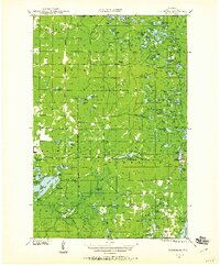 1944 Drummond1959 Print · USGSBayfield County’s forest and lake country is captured here in the mid-forties, centered on the mill town of Drummond. Genealogists and researchers can locate rural landmarks like Hall Sch, the Old Chippewa Camp Ground, and a legacy CCC Camp.2 unique versions available
 - 1947 Map of Drummond
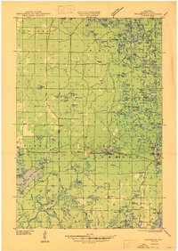 1947 Drummond1947 Print · USGSBayfield County's timber and lake country comes into focus in the years following World War II. Researchers can locate remote schoolhouses like Hall Sch and Barnes Sch. or trace the footprint of the Delta CCC Camp (Abandoned).2 unique versions available
 - 1953 Map of Ashland, 1964 Print
 1953 Ashland1964 Print · USGSNorthern Wisconsin's lakefront and timberlands are seen here in the mid-1950s, showing the intersection of industrial rail lines and vast wilderness. Genealogists and historians can trace the Soo Line through rail towns like Mellen or locate family roots in the Apostle Islands and Bad River Indian Reservation.3 unique versions available
 - 1958 Map of Ashland
 1958 Ashland1958 Print · USGSCoastal Wisconsin and the Michigan borderlands meet here in the late fifties, dominated by the timbered expanses and iron-rich ranges. Genealogists can trace family footprints in settlements like Odanah and Montreal, or locate landmarks such as the Coast Guard Station and Agricultural Experiment Station.
 - 1971 Map of Drummond, 1973 Print
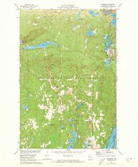 1971 Drummond1973 Print · USGSBayfield County's timberlands and glacial lakes are captured here in the early seventies, centered on the historic company town of Drummond. Genealogists and researchers can trace the rail-and-water geography of the era, from the Chicago and North Western tracks to remote landmarks like the Lookout Tower and Lake Dinner Camp.3 unique versions available
 - 1980 Map of Solon Springs
 1980 Solon Springs1980 Print · USGSNorthern Wisconsin in the early eighties was a landscape of dense timber and sprawling glacial waters. Trace the legacy of the Chicago and North Western rail line through Solon Springs, Hayward, and Minong at this pivotal moment.
 - 2005 Map of Drummond, 2006 Print
 2005 Drummond2006 Print · USGSThe Northwoods of Bayfield County are captured here during a period of forest management and preservation within the Chequamegon-Nicolet National Forest. You can trace the North Country National Scenic Trail through the Drummond area or locate the UW Field Station near Pigeon Lake.
 - 2022 Map of Drummond, 2022 Print
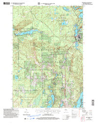
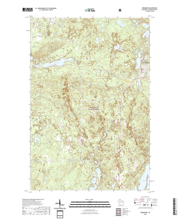 2022 Drummond2022 Print · USGSDrummond and the surrounding Northwoods appear in the early 2020s as a haven of glacial lakes and forest trails. Researchers can locate the Drummond Cem, follow the Bear-Paw Trl, or explore the shores of Pigeon Lake and Lake Owen.
End of results
Showing maps 1-8 of 8
Top cities near Lake Owen
Frequently asked questions
- What are the different types of historical maps available for Lake Owen?
- What is the oldest map of Lake Owen?
- Where can I purchase historical maps of Lake Owen for my home or office?
- Where can I download high-res historical maps of Lake Owen?
- Are there historical topographic maps available for Lake Owen?
- Is there historical aerial imagery available for Lake Owen?
- Where are historical maps of Lake Owen sourced from?