
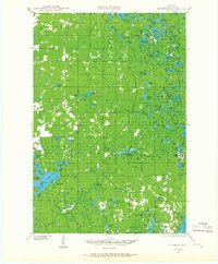
1944 Map of Drummond
USGS Topo · Published 1959About this map
The timberlands and glacial lake country of Bayfield County are defined here by the lumbering and conservation history surrounding Drummond. Surveyed just after the war, the landscape shows a transition from early industrial logging to recreational and managed forest use. Evidence of the region's logging past is visible in the network of forest roads and namesake settlements like Camp Two and Camp Nine, while the CCC Camp near Bass Lake reflects the Great Depression-era work programs that helped restore these woods. Isolated rural life is anchored by a series of one-room schoolhouses, including Hall Sch, Maple Grove Sch, and Pease Sch, spaced to serve the scattered families living within the National Forest boundaries. The northern portion of the map is dominated by a dense cluster of water bodies like Muskellunge Lake and Delta Lake, providing a detailed look at the drainage patterns of the East Fork White River.
Find a feature on this map
132 named features on this map. Tap any name to fly to it.
Don’t see what you’re looking for? This feature index may not catch every label — zoom into the map to look around manually.
Map Details
Editions of this 1944 Drummond Map
2 editions found
Other maps of this area

1943 · Iron Lake
USGS Topo · 1:48,000

1943 · Namekagon Lake
USGS Topo · 1:48,000

1944 · Moquah
USGS Topo · 1:48,000

1944 · Grandview
USGS Topo · 1:48,000

1944 · Hayward
USGS Topo · 1:48,000

1945 · Namekagon Lake
USGS Topo · 1:48,000

1945 · Highland
USGS Topo · 1:48,000

1947 · Drummond
USGS Topo · 1:48,000

1947 · Moquah
USGS Topo · 1:48,000

1947 · Brule
USGS Topo · 1:48,000