1960s Maps of Sand Bay, Russell
Explore 2 historic maps of Sand Bay from the 1960s. These maps offer a rare glimpse into what life looked like during the 1960s — showing old roads, neighborhoods, homes, and landmarks that have changed or disappeared over time.
Whether you're researching your family's past, planning a metal detecting trip, or studying how Sand Bay's landscape evolved across the 1960s, these high-resolution maps are a powerful tool for exploring the history of this region.
- Focus on a specific era: All maps on this page are from the 1960s, giving you a focused view of this time period.
- See what’s changed: Compare century-old streets, trails, and buildings to today's modern landscape using overlays and satellite layers.
- Research with precision: Use these maps for genealogy, historical research, land use analysis, or educational projects.
- View, download, or print: Maps are fully viewable online in high resolution, and can be downloaded or printed for your own records.
Start exploring Sand Bay's history through authentic maps from the 1960s. This is your window into the past.
Sand Bay, Russell maps
(2)- 1964 Map of Sand Island, 1965 Print
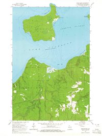 1964 Sand Island1965 Print · USGSBayfield County's northern coast and the Apostle Islands come into focus during the mid-sixties, showing the intersection of tribal lands and maritime navigation. You can trace the trails and lighthouse on Sand Island or locate resources like the Gravel Pits near the Raspberry River.2 unique versions available
 - 1964 Map of Bayfield, 1965 Print
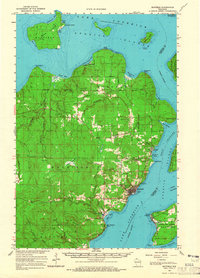 1964 Bayfield1965 Print · USGSThe Bayfield Peninsula and Apostle Islands are captured in the mid-1960s, showing the intersection of tribal lands and Lake Superior maritime life. Researchers can trace the Chicago and North Western rail line and locate landmarks like the Bayfield State Fish Hatchery and Calvary Cem.
End of results
Showing maps 1-2 of 2
Top cities near Sand Bay
Frequently asked questions
- What are the different types of historical maps available for Sand Bay?
- What is the oldest map of Sand Bay?
- Where can I purchase historical maps of Sand Bay for my home or office?
- Where can I download high-res historical maps of Sand Bay?
- Are there historical topographic maps available for Sand Bay?
- Is there historical aerial imagery available for Sand Bay?
- Where are historical maps of Sand Bay sourced from?