1980s Maps of Green Grove, Wisconsin
Explore 5 historic maps of Green Grove from the 1980s. These maps offer a rare glimpse into what life looked like during the 1980s — showing old roads, neighborhoods, homes, and landmarks that have changed or disappeared over time.
Whether you're researching your family's past, planning a metal detecting trip, or studying how Green Grove's landscape evolved across the 1980s, these high-resolution maps are a powerful tool for exploring the history of this region.
- Focus on a specific era: All maps on this page are from the 1980s, giving you a focused view of this time period.
- See what’s changed: Compare century-old streets, trails, and buildings to today's modern landscape using overlays and satellite layers.
- Research with precision: Use these maps for genealogy, historical research, land use analysis, or educational projects.
- View, download, or print: Maps are fully viewable online in high resolution, and can be downloaded or printed for your own records.
Start exploring Green Grove's history through authentic maps from the 1980s. This is your window into the past.
Green Grove, WI maps
(5)- 1981 Map of Curtiss, 1982 Print
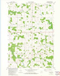 1981 Curtiss1982 Print · USGSCurtiss and the surrounding Clark County townships are shown here in the early eighties as a settled agricultural landscape shaped by the Popple River. Genealogists and researchers can trace family landmarks like Pine Hill Cem, Norwegian Ch, and the Old Railroad Grade.
 - 1981 Map of Riplinger, 1982 Print
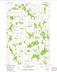 1981 Riplinger1982 Print · USGSClark County dairy lands in the early eighties are mapped here with a focus on rural township life. Genealogists can trace family roots through numerous sites like St Johns Ch, Luther Cem, and the settlement at Riplinger.
 - 1982 Map of Greenwood
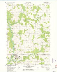 1982 Greenwood1982 Print · USGSGreenwood and the Black River valley are shown here in the early 1980s as the landscape of central Clark County matured. Genealogists and local historians can trace the foundations of the community at St Marys Cem, the West Beaver Ch, and the old settlement at Behringer.
 - 1982 Map of Owen
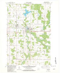 1982 Owen1982 Print · USGSThe adjacent towns of Withee and Owen define this Clark County landscape in the early eighties as the SOO LINE RAILROAD corridor hums with activity. Genealogists can locate family landmarks like Nazareth Cem, Longwood Cem, and St John Ch.
 - 1984 Map of Marshfield, 1985 Print
 1984 Marshfield1985 Print · USGSCentral Wisconsin's dairy heartland comes into focus during the mid-eighties as a busy network of rail and farm towns. Researchers can trace the path of the Soo Line, identify the grounds of McMillan State Wildlife Area, and locate smaller settlements like Spokeville and Tioga.2 unique versions available
End of results
Showing maps 1-5 of 5
Top cities near Green Grove
- Medford historical maps
- Spencer historical maps
- Abbotsford historical maps
- Loyal historical maps
- Colby historical maps
- Little Black historical maps
See more
Top neighborhoods of Green Grove
Frequently asked questions
- What are the different types of historical maps available for Green Grove?
- What is the oldest map of Green Grove?
- Where can I purchase historical maps of Green Grove for my home or office?
- Where can I download high-res historical maps of Green Grove?
- Are there historical topographic maps available for Green Grove?
- Is there historical aerial imagery available for Green Grove?
- Where are historical maps of Green Grove sourced from?