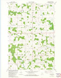
1981 Map of Curtiss
USGS Topo · Published 1982About this map
The village of Curtiss serves as the central hub of this agricultural landscape in Clark County, positioned where the Fourth Principal Meridian bisects the terrain. Local history and genealogy are anchored by landmarks like the Norwegian Ch, St Paul Ch, and the Pine Hill Cem located near Pine Hill. The transition of local transportation is evident in the Old Railroad Grade running through the center of the sheet, while modern infrastructure is represented by the Airport on Airport Road and a Radio Tower near the community of Atwood. The drainage of the area is defined by the branching tributaries of the Popple River, including the North Fork Popple River, South Fork Popple River, and East Fork Popple River, which weave through the townships of Hoard, Mayville, Green Grove, and Colby.
Find a feature on this map
31 named features on this map. Tap any name to fly to it.
Don’t see what you’re looking for? This feature index may not catch every label — zoom into the map to look around manually.
Map Details
Editions of this 1981 Curtiss Map
This is the sole edition of this map. No revisions or reprints were ever made.
Other maps of this area

1951 · Lublin
USGS Topo · 1:48,000

1951 · Medford
USGS Topo · 1:48,000

1953 · Abbotsford
USGS Topo · 1:48,000

1953 · Owen
USGS Topo · 1:48,000

1953 · Eau Claire
USGS Topo · 1:250,000

1953 · Rice Lake
USGS Topo · 1:250,000

1958 · Eau Claire
USGS Topo · 1:250,000

1959 · Rice Lake
USGS Topo · 1:250,000

1963 · Abbotsford
USGS Topo · 1:62,500

1963 · Owen
USGS Topo · 1:62,500