1970s Maps of Hendren, Wisconsin
Explore 3 historic maps of Hendren from the 1970s. These maps offer a rare glimpse into what life looked like during the 1970s — showing old roads, neighborhoods, homes, and landmarks that have changed or disappeared over time.
Whether you're researching your family's past, planning a metal detecting trip, or studying how Hendren's landscape evolved across the 1970s, these high-resolution maps are a powerful tool for exploring the history of this region.
- Focus on a specific era: All maps on this page are from the 1970s, giving you a focused view of this time period.
- See what’s changed: Compare century-old streets, trails, and buildings to today's modern landscape using overlays and satellite layers.
- Research with precision: Use these maps for genealogy, historical research, land use analysis, or educational projects.
- View, download, or print: Maps are fully viewable online in high resolution, and can be downloaded or printed for your own records.
Start exploring Hendren's history through authentic maps from the 1970s. This is your window into the past.
Hendren, WI maps
(3)- 1979 Map of Rock Dam Lake, 1980 Print
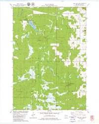 1979 Rock Dam Lake1980 Print · USGSClark County's timber and river country is captured in the late seventies, showing a landscape defined by water control and forest management. Researchers can trace the path of the Old RR Grade near Tioga or locate rural landmarks like Abbott Ranch and Rock Dam County Park.
 - 1979 Map of Mead Lake West, 1980 Print
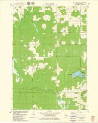 1979 Mead Lake West1980 Print · USGSClark County in the late seventies is captured here at the junction of the Eau Claire River forks and the recreation waters of Mead Lake. Genealogists and local historians can locate Butler Cem, the Townhall, and family-named water features like Dickison Creek.
 - 1979 Map of Willard, 1980 Print
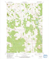 1979 Willard1980 Print · USGSWisconsin's central dairy and timber country is well-documented in the late seventies, showing the rural townships of Hendren and Eaton. Researchers can trace the legacy of the logging era via the Old Railroad Grade or find local family roots at Willard Cem and Holy Family Ch.2 unique versions available
End of results
Showing maps 1-3 of 3
Top cities near Hendren
- Stanley historical maps
- Neillsville historical maps
- Thorp historical maps
- Edson historical maps
- Greenwood historical maps
- Owen historical maps
See more
Top neighborhoods of Hendren
Frequently asked questions
- What are the different types of historical maps available for Hendren?
- What is the oldest map of Hendren?
- Where can I purchase historical maps of Hendren for my home or office?
- Where can I download high-res historical maps of Hendren?
- Are there historical topographic maps available for Hendren?
- Is there historical aerial imagery available for Hendren?
- Where are historical maps of Hendren sourced from?