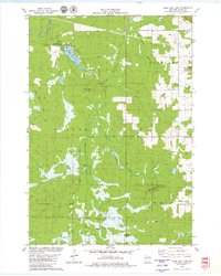
1979 Map of Rock Dam Lake
USGS Topo · Published 1980About this map
Rock Dam Lake serves as a focal point for this Clark County landscape, where the Eau Claire River and Hay Creek meet. The area is defined by its water management and forestry history, evidenced by sequential structures like Dam No 16, Dam No 12, and Dam No 10 along the drainage ways. The small settlement of Tioga is situated near the Tioga Lookout Tower, a critical point for forest monitoring. Transport history is visible through the Old RR Grade and Koehler Road, which cut through the timbered sections of Hendren, Foster, and Seif. Distinctive topographical markers such as Hay Creek Mound and Bald Peak rise above the surrounding wetlands, while the Abbott Ranch and scattered gravel pits point to the local rural economy of the late 1970s.
Find a feature on this map
32 named features on this map. Tap any name to fly to it.
Don’t see what you’re looking for? This feature index may not catch every label — zoom into the map to look around manually.
Map Details
Editions of this 1979 Rock Dam Lake Map
This is the sole edition of this map. No revisions or reprints were ever made.
Other maps of this area

1948 · Fairchild
USGS Topo · 1:62,500

1949 · Fairchild
USGS Topo · 1:62,500

1952 · Stanley
USGS Topo · 1:62,500

1953 · Neillsville
USGS Topo · 1:62,500

1953 · Owen
USGS Topo · 1:48,000

1953 · Eau Claire
USGS Topo · 1:250,000

1958 · Eau Claire
USGS Topo · 1:250,000

1963 · Owen
USGS Topo · 1:62,500

1964 · Eau Claire
USGS Topo · 1:250,000
1979 · Horse Creek
USGS Topo · 1:24,000