
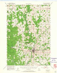
1953 Map of Neillsville
USGS Topo · Published 1955About this map
Neillsville serves as the focal point of this mid-century survey, situated at the confluence of O'Neill Creek and the Black River. The city's industrial and transportation ties are evident through the junction of the Chicago and North Western and an Old Railroad Grade that speaks to earlier logging or freight routes. To the north and west, the landscape is defined by glacial features and early 20th-century agrarian settlement, including distinctive landmarks like Neillsville Mounds and Christie Mound.
Find a feature on this map
77 named features on this map. Tap any name to fly to it.
Don’t see what you’re looking for? This feature index may not catch every label — zoom into the map to look around manually.
Map Details
Editions of this 1953 Neillsville Map
2 editions found
Other maps of this area

1924 · Black River Falls
USGS Topo · 1:62,500

1926 · Black River Falls
USGS Topo · 1:62,500

1948 · Fairchild
USGS Topo · 1:62,500

1949 · Fairchild
USGS Topo · 1:62,500

1952 · Stanley
USGS Topo · 1:62,500

1953 · Abbotsford
USGS Topo · 1:48,000

1953 · Owen
USGS Topo · 1:48,000

1953 · Eau Claire
USGS Topo · 1:250,000

1954 · Granton
USGS Topo · 1:62,500

1957 · City Point
USGS Topo · 1:48,000