
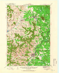
1924 Map of Black River Falls
USGS Topo · Published 1963About this map
Black River Falls serves as the focal point of this 1920s topography, situated where the Black River cuts through the transition from central plains to terminal moraine country. The area’s educational and religious foundations are prominent, featuring the Winnebago Mission and an extensive network of country schools like Houghtonburg School and Cloverdale School. Industry and infrastructure are anchored by the Charter Oak Mill and the intersection of the Chicago St Paul Minneapolis and Omaha and Green Bay and Western railroads, which facilitated trade through Merrillan and Alma Center. Geologically, the landscape is defined by distinctive sandstone buttes and landmarks such as Silver Mound, Saddle Mound, and Castle Rock, while the winding courses of Halls Creek and Trempealeau River drain the surrounding Garden Valley.
Find a feature on this map
68 named features on this map. Tap any name to fly to it.
Don’t see what you’re looking for? This feature index may not catch every label — zoom into the map to look around manually.
Map Details
Editions of this 1924 Black River Falls Map
2 editions found
Other maps of this area

1926 · Black River Falls
USGS Topo · 1:62,500

1926 · North Bend
USGS Topo · 1:62,500

1927 · Blair
USGS Topo · 1:62,500

1928 · Melrose
USGS Topo · 1:48,000

1929 · North Bend
USGS Topo · 1:62,500

1935 · Osseo
USGS Topo · 1:48,000

1940 · Osseo
USGS Topo · 1:62,500

1947 · Millston
USGS Topo · 1:62,500

1948 · Fairchild
USGS Topo · 1:62,500

1949 · Millston
USGS Topo · 1:62,500