
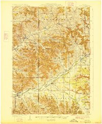
1927 Map of Blair
USGS Topo · Published 1927About this map
The Trempealeau River valley serves as the primary artery for settlement and commerce throughout this region of western Wisconsin. Along its banks, the Green Bay and Western railroad connects established rural hubs like Blair, Taylor, and Hixton. The landscape is defined by its distinctive coulee topography, where family-named schools such as Schermerhorn School, Haskelhus School, and Thorson School appear tucked into the narrow valleys. This drainage pattern of ridges and deep ravines, like Skutley Coulee and Fitch Coulee, reflects a highly localized agricultural society where schools and churches were positioned to be accessible by the winding roads following the water. The survey also captures early regional infrastructure including State Highway No 11 and the small-scale settlement patterns of Pigeon Falls and Sechlerville.
Find a feature on this map
71 named features on this map. Tap any name to fly to it.
Don’t see what you’re looking for? This feature index may not catch every label — zoom into the map to look around manually.
Map Details
Editions of this 1927 Blair Map
2 editions found
Other maps of this area

1924 · Black River Falls
USGS Topo · 1:62,500

1926 · Black River Falls
USGS Topo · 1:62,500

1926 · North Bend
USGS Topo · 1:62,500

1926 · Whitehall
USGS Topo · 1:62,500

1927 · Strum
USGS Topo · 1:62,500

1928 · Melrose
USGS Topo · 1:48,000

1929 · Whitehall
USGS Topo · 1:62,500

1929 · Galesville
USGS Topo · 1:62,500

1929 · North Bend
USGS Topo · 1:62,500

1930 · Strum
USGS Topo · 1:62,500