1926 Map of Whitehall
USGS Topo · Published 1972About this map
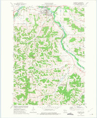
Whitehall serves as the focal point of this 1920s survey, situated along the Trempealeau River and the critical line of the Green Bay and Western Railroad. The landscape is defined by its coulee and valley systems, where family names are etched into the geography, such as Johnson Valley Creek and Wickham Valley Creek. The density of rural one-room schools like Sunny Slope Sch, New City Sch, and Korpal Valley Sch reveals a highly decentralized agricultural society just before the consolidation of the mid-20th century. Notable institutional landmarks including the Trempealeau County Asylum stand on the outskirts of the county seat. Further north, the high ground of Chimney Rock overlooks a network of early motor routes, including the predecessor to State Trunk Highway No 53, which connected smaller hamlets like Coral City and Pleasantville.
Find a feature on this map
80 named features on this map. Tap any name to fly to it.
Don’t see what you’re looking for? This feature index may not catch every label — zoom into the map to look around manually.
Map Details
Editions of this 1926 Whitehall Map
This is the sole edition of this map. No revisions or reprints were ever made.
Historical Maps of Arcadia Through Time
4 maps found