
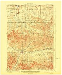
1932 Map of Mondovi
USGS Topo · Published 1932About this map
The Buffalo River valley serves as the central corridor for this 1930s landscape, where the city of Mondovi anchors a network of rural townships including Albany, Naples, and Drammen. The map reveals a highly localized education system defined by numerous neighborhood schoolhouses, such as White Block Sch, Little Red Sch, and Paradise Valley Sch, each serving specific drainage basins and valleys. Transportation is dictated by the water, with the Chicago Milwaukee and St Paul and Pacific RR following the curves of the Chippewa River near Caryville in the north, while the Chicago and Northwestern River line traces the Buffalo River valley. Small commercial hubs like Rock Falls and Candy Corners appear at strategic crossroads, supporting a landscape of coulees and ridges where family-named landmarks like Thompson Valley Sch and Gibson Sch NO 1 mark the settled hillsides.
Find a feature on this map
74 named features on this map. Tap any name to fly to it.
Don’t see what you’re looking for? This feature index may not catch every label — zoom into the map to look around manually.
Map Details
Editions of this 1932 Mondovi Map
2 editions found
Other maps of this area

1926 · Whitehall
USGS Topo · 1:62,500

1927 · Strum
USGS Topo · 1:62,500

1929 · Whitehall
USGS Topo · 1:62,500

1929 · Durand
USGS Topo · 1:62,500

1930 · Strum
USGS Topo · 1:62,500

1932 · Gilmanton
USGS Topo · 1:62,500

1932 · Durand
USGS Topo · 1:62,500

1932 · Alma
USGS Topo · 1:62,500

1934 · Elk Mound
USGS Topo · 1:62,500

1934 · Chippewa Falls
USGS Topo · 1:62,500