
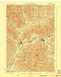
1929 Map of Whitehall
USGS Topo · Published 1929About this map
The Trempealeau River carves a deep path through these Wisconsin hills, anchoring the primary settlements of Whitehall, Independence, and Arcadia. This 1920s landscape is defined by its coulees and named valleys, such as Borst Valley and Bruce Valley, where the drainage patterns dictated the placement of dozens of rural schoolhouses. The Green Bay and Western RR tracks follow the river's bend, connecting the valley to the larger region during a period of steady agrarian development. One notable landmark of the era is the County Asylum situated just west of the county seat. This map reveals the transition between old crossroads like Coral City and Pleasantville and the growing rail towns. Genealogists will find a wealth of local identifiers, from Weaver Hill to a dense network of one-room schools like Sunny Slope Sch and Wojcik Sch that served the many family farms in the surrounding townships.
Find a feature on this map
93 named features on this map. Tap any name to fly to it.
Don’t see what you’re looking for? This feature index may not catch every label — zoom into the map to look around manually.
Map Details
Editions of this 1929 Whitehall Map
2 editions found
Other maps of this area

1926 · North Bend
USGS Topo · 1:62,500

1926 · Whitehall
USGS Topo · 1:62,500

1927 · Blair
USGS Topo · 1:62,500

1927 · Strum
USGS Topo · 1:62,500

1929 · Fountain City
USGS Topo · 1:62,500

1929 · Galesville
USGS Topo · 1:62,500

1929 · North Bend
USGS Topo · 1:62,500

1930 · Strum
USGS Topo · 1:62,500

1932 · Gilmanton
USGS Topo · 1:62,500

1932 · Mondovi
USGS Topo · 1:62,500