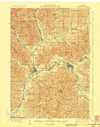
1929 Map of Whitehall
USGS Topo · Published 1929About this map
The Trempealeau River valley serves as the central artery for this Western Wisconsin landscape, dictating the placement of the major 1920s settlements. The Green Bay and Western Railroad follows the river's path, connecting the hub at Whitehall to Independence and Arcadia. Away from the rail line, the topography is defined by a dense network of coulees and valleys, many bearing family names like Wickham Valley and Borst Valley. This era is marked by a remarkable concentration of local education, with dozens of rural schoolhouses such as Sunny Slope Sch and Wojcik Sch serving the farming community. The map also identifies the Green County Asylum near Whitehall, reflecting early 20th-century social infrastructure. Early state transit is documented through routes like State Trunk Highway No 93, which navigates the complex terrain between the river and landmarks like Square Bluff.
Find a feature on this map
77 named features on this map. Tap any name to fly to it.
Don’t see what you’re looking for? This feature index may not catch every label — zoom into the map to look around manually.
Map Details
Editions of this 1929 Whitehall Map
2 editions found
Other maps of this area

1926 · North Bend
USGS Topo · 1:62,500

1926 · Whitehall
USGS Topo · 1:62,500

1927 · Blair
USGS Topo · 1:62,500

1927 · Strum
USGS Topo · 1:62,500

1929 · Whitehall
USGS Topo · 1:62,500

1929 · Fountain City
USGS Topo · 1:62,500

1929 · Galesville
USGS Topo · 1:62,500

1929 · North Bend
USGS Topo · 1:62,500

1930 · Strum
USGS Topo · 1:62,500

1932 · Gilmanton
USGS Topo · 1:62,500