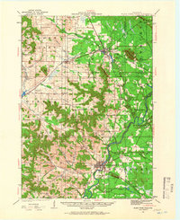
1924 Map of Black River Falls
USGS Topo · Published 1966About this map
The Black River Falls vicinity in the mid-1920s is defined by its dramatic topographic relief and a dense network of rural one-room schoolhouses. Notable peaks like Silver Mound, Saddle Mound, and Castle Mound punctuate the landscape, serving as prominent landmarks for a community largely organized around local schools such as Leverett School, Houghtonburg School, and the Squaw Creek School. The settlement pattern follows the Black River and its numerous tributaries, including Halls Creek and Levis Creek, where early industry is represented by the Charter Oak Mills south of the main town. Two major railroads, the Chicago St Paul Minneapolis and Omaha and the Green Bay and Western, intersect at Merrillan, facilitating the region's movement of timber and agricultural goods. To the east, the Winnebago Mission sits within the Komensky area, reflecting the cultural layers of the region beyond the rail-line hubs like Alma Center.
Find a feature on this map
63 named features on this map. Tap any name to fly to it.
Don’t see what you’re looking for? This feature index may not catch every label — zoom into the map to look around manually.
Map Details
Editions of this 1924 Black River Falls Map
2 editions found
Other maps of this area

1924 · Black River Falls
USGS Topo · 1:62,500

1926 · Black River Falls
USGS Topo · 1:62,500

1926 · North Bend
USGS Topo · 1:62,500

1927 · Blair
USGS Topo · 1:62,500

1928 · Melrose
USGS Topo · 1:48,000

1929 · North Bend
USGS Topo · 1:62,500

1935 · Osseo
USGS Topo · 1:48,000

1940 · Osseo
USGS Topo · 1:62,500

1947 · Millston
USGS Topo · 1:62,500

1948 · Fairchild
USGS Topo · 1:62,500