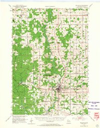
1953 Map of Neillsville
USGS Topo · Published 1966About this map
The Black River carves a central path through this mid-century portrait of Clark County, anchoring the regional hub of Neillsville. The landscape is a patchwork of small-scale agriculture and timber, evidenced by the high density of rural schoolhouses such as West Eaton Sch, Happy Hollow Sch, and the Janesville Sch (Abandoned). Transport infrastructure is transitionary, featuring the Chicago and North Western rail line alongside an Old Railroad Grade in the south, while the Neillsville Airport and underground telephone cable represent modernizing shifts. Topographic interests like the Neillsville Mounds and Middle Mound punctuate the river valley, while several family-history markers, including the Willard National Cem and Seif Cem, provide specific touchstones for genealogical research in townships like Hendren and Eaton.
Find a feature on this map
73 named features on this map. Tap any name to fly to it.
Don’t see what you’re looking for? This feature index may not catch every label — zoom into the map to look around manually.
Map Details
Editions of this 1953 Neillsville Map
2 editions found
Other maps of this area

1924 · Black River Falls
USGS Topo · 1:62,500

1926 · Black River Falls
USGS Topo · 1:62,500

1948 · Fairchild
USGS Topo · 1:62,500

1949 · Fairchild
USGS Topo · 1:62,500

1952 · Stanley
USGS Topo · 1:62,500

1953 · Neillsville
USGS Topo · 1:62,500

1953 · Abbotsford
USGS Topo · 1:48,000

1953 · Owen
USGS Topo · 1:48,000

1953 · Eau Claire
USGS Topo · 1:250,000

1954 · Granton
USGS Topo · 1:62,500