
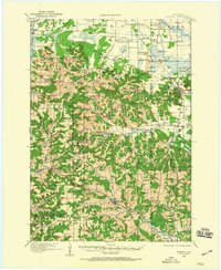
1964 Map of Eau Claire
USGS Topo · Published 1964About this map
Eau Claire and Chippewa Falls anchor the north-central portion of this mid-century landscape, where the confluence of the Chippewa River and Eau Claire River drove early regional development. The map details a transition from the agricultural plains and river valleys of the west to the dense marshlands and military grounds of the east. Large-scale water management is evident in the presence of the Petenwell Flowage, Castle Rock Flowage, and Lake Wissota.
Find a feature on this map
206 named features on this map. Tap any name to fly to it.
Don’t see what you’re looking for? This feature index may not catch every label — zoom into the map to look around manually.
Map Details
Editions of this 1964 Eau Claire Map
This is the sole edition of this map. No revisions or reprints were ever made.
Other maps of this area

1902 · Marathon
USGS Topo · 1:125,000

1909 · Sparta
USGS Topo · 1:62,500

1916 · Tomah
USGS Topo · 1:62,500
1919 · Kendall
USGS Topo · 1:62,500

1921 · Mauston
USGS Topo · 1:62,500
1921 · Kendall
USGS Topo · 1:62,500

1924 · Black River Falls
USGS Topo · 1:62,500

1926 · Black River Falls
USGS Topo · 1:62,500

1926 · North Bend
USGS Topo · 1:62,500

1926 · Whitehall
USGS Topo · 1:62,500