1900-1909 Maps of Caledonia, Wisconsin
Explore 4 historic maps of Caledonia from 1900-1909. These maps offer a rare glimpse into what life looked like during the 1900s — showing old roads, neighborhoods, homes, and landmarks that have changed or disappeared over time.
Whether you're researching your family's past, planning a metal detecting trip, or studying how Caledonia's landscape evolved across the 1900s, these high-resolution maps are a powerful tool for exploring the history of this region.
- Focus on a specific era: All maps on this page are from the 1900s, giving you a focused view of this time period.
- See what’s changed: Compare century-old streets, trails, and buildings to today's modern landscape using overlays and satellite layers.
- Research with precision: Use these maps for genealogy, historical research, land use analysis, or educational projects.
- View, download, or print: Maps are fully viewable online in high resolution, and can be downloaded or printed for your own records.
Start exploring Caledonia's history through authentic maps from the 1900s. This is your window into the past.
Caledonia, WI maps
(4)- 1901 Map of Poynette
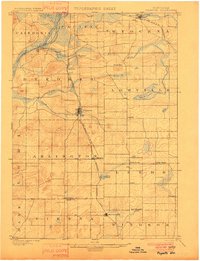 1901 Poynette1901 Print · USGSWisconsin's rural heartland comes into focus at the dawn of the twentieth century, anchored by the railway corridor and the winding river. Researchers can trace the early footprints of Poynette, Wyocena, and Dekorra alongside small junctions like Morrisonville and Arlington.3 unique versions available
 - 1902 Map of Portage
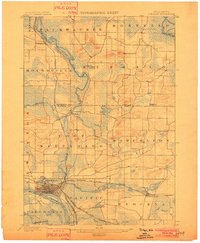 1902 Portage1902 Print · USGSPortage and the surrounding marshlands of Columbia County appear here at the turn of the century, centered on the strategic divide between the Wisconsin River and Fox River. Genealogists and rail historians can trace the early footprints of Portage, the canal-era site of Fort Hope, and rural communities like Pardeeville and Marcellon.3 unique versions available
 - 1902 Map of Briggsville
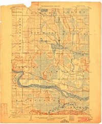 1902 Briggsville1902 Print · USGSThe Wisconsin River valley at the turn of the century shows a landscape of river-and-rail industry. Trace the early township developments of Lewiston and Douglas, or locate original landmarks like the Levee and Big Spring.4 unique versions available
 - 1908 Map of Baraboo
 1908 Baraboo1908 Print · USGSSauk and Columbia counties at the close of the nineteenth century reveal a landscape shaped by the Wisconsin River and early rail expansion. Trace the rail lines through Baraboo and Lodi, or locate old river landings near Merrimac and Sauk.
End of results
Showing maps 1-4 of 4
Top cities near Caledonia
- Baraboo historical maps
- DeForest historical maps
- Portage historical maps
- Windsor historical maps
- Prairie du Sac historical maps
- Lake Delton historical maps
See more
Top neighborhoods of Caledonia
Frequently asked questions
- What are the different types of historical maps available for Caledonia?
- What is the oldest map of Caledonia?
- Where can I purchase historical maps of Caledonia for my home or office?
- Where can I download high-res historical maps of Caledonia?
- Are there historical topographic maps available for Caledonia?
- Is there historical aerial imagery available for Caledonia?
- Where are historical maps of Caledonia sourced from?