1970s Maps of Lodi, Wisconsin
Explore 2 historic maps of Lodi from the 1970s. These maps offer a rare glimpse into what life looked like during the 1970s — showing old roads, neighborhoods, homes, and landmarks that have changed or disappeared over time.
Whether you're researching your family's past, planning a metal detecting trip, or studying how Lodi's landscape evolved across the 1970s, these high-resolution maps are a powerful tool for exploring the history of this region.
- Focus on a specific era: All maps on this page are from the 1970s, giving you a focused view of this time period.
- See what’s changed: Compare century-old streets, trails, and buildings to today's modern landscape using overlays and satellite layers.
- Research with precision: Use these maps for genealogy, historical research, land use analysis, or educational projects.
- View, download, or print: Maps are fully viewable online in high resolution, and can be downloaded or printed for your own records.
Start exploring Lodi's history through authentic maps from the 1970s. This is your window into the past.
Lodi, WI maps
(2)- 1974 Map of Baraboo SE, 1976 Print
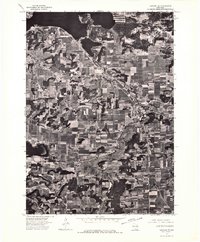 1974 Baraboo SE1976 Print · USGSThe river valley and surrounding farmsteads are captured in this mid-1970s aerial survey as the region balanced its rural roots with growing town centers. Researchers can trace the layout of Lodi and the shoreline of Lake Wisconsin during this era.
 - 1975 Map of Lodi, 1978 Print
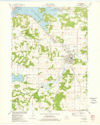 1975 Lodi1978 Print · USGSLodi and the surrounding glacial valley are captured in the mid-seventies, showing a landscape defined by the railroad and the widening Wisconsin River. Researchers can trace family-named homesteads along Reynolds Road or locate historic burial sites like St Patricks Cem and Garden Bluff Cem.
End of results
Showing maps 1-2 of 2
Top cities near Lodi
- Madison historical maps
- Middleton historical maps
- Waunakee historical maps
- Baraboo historical maps
- DeForest historical maps
- Portage historical maps
See more
Top neighborhoods of Lodi
Frequently asked questions
- What are the different types of historical maps available for Lodi?
- What is the oldest map of Lodi?
- Where can I purchase historical maps of Lodi for my home or office?
- Where can I download high-res historical maps of Lodi?
- Are there historical topographic maps available for Lodi?
- Is there historical aerial imagery available for Lodi?
- Where are historical maps of Lodi sourced from?