1980s Maps of Lowville, Wisconsin
Explore 4 historic maps of Lowville from the 1980s. These maps offer a rare glimpse into what life looked like during the 1980s — showing old roads, neighborhoods, homes, and landmarks that have changed or disappeared over time.
Whether you're researching your family's past, planning a metal detecting trip, or studying how Lowville's landscape evolved across the 1980s, these high-resolution maps are a powerful tool for exploring the history of this region.
- Focus on a specific era: All maps on this page are from the 1980s, giving you a focused view of this time period.
- See what’s changed: Compare century-old streets, trails, and buildings to today's modern landscape using overlays and satellite layers.
- Research with precision: Use these maps for genealogy, historical research, land use analysis, or educational projects.
- View, download, or print: Maps are fully viewable online in high resolution, and can be downloaded or printed for your own records.
Start exploring Lowville's history through authentic maps from the 1980s. This is your window into the past.
Lowville, WI maps
(4)- 1980 Map of North Bristol
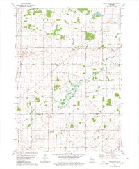 1980 North Bristol1980 Print · USGSThe agricultural heartland of Columbia and Dane Counties is captured here in the late 1970s. Local researchers can trace family lands and rural landmarks like Hampden Cemetery, the Hampden School, and the winding Crawfish River.
 - 1980 Map of Rio, 1981 Print
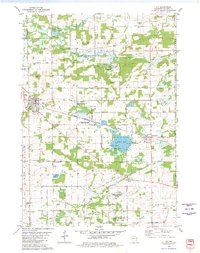 1980 Rio1981 Print · USGSColumbia County is shown in the early 1980s as a vital intersection of rail transport and wildlife conservation. Genealogists and local historians can trace family locations near Rio and Doylestown, or locate landmarks like the Bonnett Prairie Cemetery and St. Joseph Cemetery.
 - 1984 Map of Wyocena
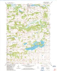 1984 Wyocena1984 Print · USGSThe village of Wyocena and the surrounding Columbia County wetlands are captured here in the mid-1980s. Local researchers can trace family landmarks like Rocky Run Cem, the Poynette State Game Farm, and the path of the Milwaukee St Paul and Pacific railroad.
 - 1984 Map of Morrisonville
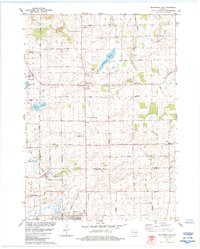 1984 Morrisonville1984 Print · USGSColumbia and Dane counties come into focus in the mid-1980s, showcasing a landscape of established rail lines and agricultural hamlets. Genealogists can trace family roots at North Windsor Church or locate ancestral plots at Greenwood Cemetery and Zion Cemetery.
End of results
Showing maps 1-4 of 4
Top cities near Lowville
- Sun Prairie historical maps
- Waunakee historical maps
- DeForest historical maps
- Portage historical maps
- Windsor historical maps
- Town of Bristol historical maps
See more
Frequently asked questions
- What are the different types of historical maps available for Lowville?
- What is the oldest map of Lowville?
- Where can I purchase historical maps of Lowville for my home or office?
- Where can I download high-res historical maps of Lowville?
- Are there historical topographic maps available for Lowville?
- Is there historical aerial imagery available for Lowville?
- Where are historical maps of Lowville sourced from?