1970s Maps of Dodge County, Wisconsin
Explore 9 historic maps of Dodge County from the 1970s. These maps offer a rare glimpse into what life looked like during the 1970s — showing old roads, neighborhoods, homes, and landmarks that have changed or disappeared over time.
Whether you're researching your family's past, planning a metal detecting trip, or studying how Dodge County's landscape evolved across the 1970s, these high-resolution maps are a powerful tool for exploring the history of this region.
- Focus on a specific era: All maps on this page are from the 1970s, giving you a focused view of this time period.
- See what’s changed: Compare century-old streets, trails, and buildings to today's modern landscape using overlays and satellite layers.
- Research with precision: Use these maps for genealogy, historical research, land use analysis, or educational projects.
- View, download, or print: Maps are fully viewable online in high resolution, and can be downloaded or printed for your own records.
Start exploring Dodge County's history through authentic maps from the 1970s. This is your window into the past.
Dodge County, WI maps
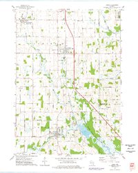
(9)- 1974 Map of Byron, 1978 Print
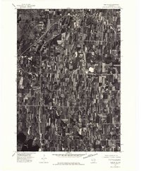
 1974 Byron1978 Print · USGSThe limestone quarries and rail lines of the Wisconsin Escarpment are captured here in the 1970s. Local researchers can trace family roots in Hamilton and South Byron or locate old industrial sites like the Kilns in Marblehead.
 - 1974 Map of Lomira, 1978 Print
 1974 Lomira1978 Print · USGSDodge County's glacial landscape and wetland conservation are captured here in the mid-seventies, featuring the expansive Theresa Marsh State Wildlife Area. Researchers can trace local heritage through numerous sites like Wayne Cem, St Pauls Sch, and the old rail stop at Theresa Station.
 - 1975 Map of Horicon NW, 1977 Print
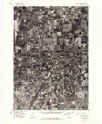
 1975 Horicon NW1977 Print · USGSDodge County in the mid-1970s is captured here in an aerial photographic survey showing the intersection of local industry and nature. Researchers can trace the residential layouts of Juneau and Horicon or explore the wild terrain of the Horicon Marsh Wildlife Area.
 - 1975 Map of Beaver Dam NE, 1977 Print
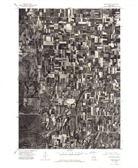
 1975 Beaver Dam NE1977 Print · USGSDodge County, Wisconsin, comes into sharp focus in the mid-1970s, showing the intersection of lakeside development and intensive agriculture. Genealogists and local historians can trace the growth of Beaver Dam and its relationship to the shores of Beaver Dam Lake.
 - 1975 Map of Waupun NW, 1977 Print
 1975 Waupun NW1977 Print · USGSThe northern outskirts of Waupun and the surrounding dairy lands are captured here in the mid-seventies. Researchers can examine the detailed rural landscape around the settlement of Ladoga and the marshy fringes of the Horicon National Wildlife Refuge.
 - 1975 Map of Horicon NE, 1977 Print
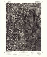
 1975 Horicon NE1977 Print · USGSDodge County farmland and the edge of a massive wetland complex are captured in this mid-seventies aerial study. Trace the residential growth of Mayville and Iron Ridge or examine the shoreline of Sinnissippi Lake.
 - 1975 Map of Waupun NE, 1977 Print
 1975 Waupun NE1977 Print · USGSFond du Lac County agriculture and small-town life are preserved in this mid-seventies aerial survey. Researchers can trace the layout of Oakfield, Lamartine, and the northern reaches of the Horicon National Wildlife Refuge.
 - 1975 Map of Waupun SE, 1977 Print
 1975 Waupun SE1977 Print · USGSDodge County agricultural lands and the eastern edge of the marsh are captured here in the mid-seventies. Researchers can trace the layout of Mayville and rural hamlets like Leroy and Kekoskee against the Horicon Marsh.
 - 1975 Map of Waupun SW, 1977 Print
 1975 Waupun SW1977 Print · USGSThe Dodge County wetlands and agricultural frontier are captured in this mid-seventies aerial survey. Researchers can trace the boundaries of the Horicon National Wildlife Refuge and the southern edge of Waupun.
End of results
Showing maps 1-9 of 9
Top cities of Dodge County
- Beaver Dam historical maps
- Mayville historical maps
- Horicon historical maps
- Juneau historical maps
- Lomira historical maps
- Lebanon historical maps
See more
Frequently asked questions
- What are the different types of historical maps available for Dodge County?
- What is the oldest map of Dodge County?
- Where can I purchase historical maps of Dodge County for my home or office?
- Where can I download high-res historical maps of Dodge County?
- Are there historical topographic maps available for Dodge County?
- Is there historical aerial imagery available for Dodge County?
- Where are historical maps of Dodge County sourced from?