1960s Maps of Clay Banks, Wisconsin
Explore 2 historic maps of Clay Banks from the 1960s. These maps offer a rare glimpse into what life looked like during the 1960s — showing old roads, neighborhoods, homes, and landmarks that have changed or disappeared over time.
Whether you're researching your family's past, planning a metal detecting trip, or studying how Clay Banks's landscape evolved across the 1960s, these high-resolution maps are a powerful tool for exploring the history of this region.
- Focus on a specific era: All maps on this page are from the 1960s, giving you a focused view of this time period.
- See what’s changed: Compare century-old streets, trails, and buildings to today's modern landscape using overlays and satellite layers.
- Research with precision: Use these maps for genealogy, historical research, land use analysis, or educational projects.
- View, download, or print: Maps are fully viewable online in high resolution, and can be downloaded or printed for your own records.
Start exploring Clay Banks's history through authentic maps from the 1960s. This is your window into the past.
Clay Banks, WI maps
(2)- 1960 Map of Sturgeon Bay, 1962 Print
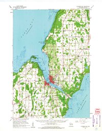 1960 Sturgeon Bay1962 Print · USGSThe Door County peninsula in the early sixties shows a bustling maritime corridor defined by the Sturgeon Bay ship canal. Researchers can locate numerous vanished country schoolhouses like Hainesville Sch, the Ahnapee and Western rail line, and family landmarks like Monument Point.
 - 1960 Map of Algoma, 1962 Print
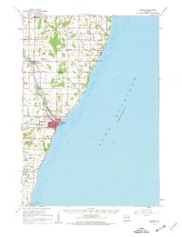 1960 Algoma1962 Print · USGSCoastal Kewaunee County thrived in the early sixties as a network of rail and water centered on the port of Algoma. Researchers can trace old family names and community foundations at Brockhausen Cem, the Kodan School, and along the Ahnapee and Western line.2 unique versions available
End of results
Showing maps 1-2 of 2
Top cities near Clay Banks
- Sturgeon Bay historical maps
- Algoma historical maps
- Brussels historical maps
- Lincoln historical maps
- Jacksonport historical maps
- Forestville historical maps
Top neighborhoods of Clay Banks
Frequently asked questions
- What are the different types of historical maps available for Clay Banks?
- What is the oldest map of Clay Banks?
- Where can I purchase historical maps of Clay Banks for my home or office?
- Where can I download high-res historical maps of Clay Banks?
- Are there historical topographic maps available for Clay Banks?
- Is there historical aerial imagery available for Clay Banks?
- Where are historical maps of Clay Banks sourced from?