2020s Maps of Egg Harbor, Wisconsin
Explore 6 historic maps of Egg Harbor from the 2020s. These maps offer a rare glimpse into what life looked like during the 2020s — showing old roads, neighborhoods, homes, and landmarks that have changed or disappeared over time.
Whether you're researching your family's past, planning a metal detecting trip, or studying how Egg Harbor's landscape evolved across the 2020s, these high-resolution maps are a powerful tool for exploring the history of this region.
- Focus on a specific era: All maps on this page are from the 2020s, giving you a focused view of this time period.
- See what’s changed: Compare century-old streets, trails, and buildings to today's modern landscape using overlays and satellite layers.
- Research with precision: Use these maps for genealogy, historical research, land use analysis, or educational projects.
- View, download, or print: Maps are fully viewable online in high resolution, and can be downloaded or printed for your own records.
Start exploring Egg Harbor's history through authentic maps from the 2020s. This is your window into the past.
Egg Harbor, WI maps
(6)- 2022 Map of Idlewild, 2022 Print
 2022 Idlewild2022 Print · USGSDoor County’s coastline near the entrance to Sturgeon Bay is mapped here in the early twenty-first century. Maritime researchers can locate Sherwood Point, trace the Water Trail along the bluffs, and identify hazards like Larsons Reef and Monument Shoal.
 - 2022 Map of Institute, 2022 Print
 2022 Institute2022 Print · USGSThe western shores of the Door Peninsula are documented here in the early twenty-first century, featuring the high overlooks of Windsong Bluff. Researchers can trace the communities of Carlsville and Institute or locate family roots at Saint John Lutheran Cem.
 - 2022 Map of Marinette East, 2022 Print
 2022 Marinette East2022 Print · USGSThe twin border cities of the Menominee River estuary are shown here in detail during the early 2020s. Trace the urban development near the Menominee County Courthouse or explore the coastal features of Seagull Bar and Green Island.
 - 2022 Map of Baileys Harbor West, 2022 Print
 2022 Baileys Harbor West2022 Print · USGSDoor County's peninsula geography is captured here in the early 2020s, showing the landscape between the Green Bay and Lake Michigan shores. Researchers can locate local landmarks like Kangaroo Lake or trace family sites at the Saint Paul Lutheran Cem and Baileys Harbor Town Cem.
 - 2022 Map of Green Island, 2022 Print
 2022 Green Island2022 Print · USGSThe waters of the northern Great Lakes are captured in this modern survey, focusing on the isolated Green Island during the early twenty-first century. Researchers can trace the aquatic boundaries where Lake Michigan meets Green Bay at the junction of Door, Marinette, and Menominee counties.
 - 2022 Map of Egg Harbor, 2022 Print
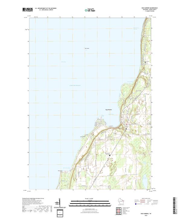 2022 Egg Harbor2022 Print · USGSThe Door County coast is captured here in the early twenty-first century, featuring the village of Egg Harbor and the settlement of Juddville. Trace local heritage through markers like the Juddville Cem, Horseshoe Bay, and the historic Cottage Row shoreline.
End of results
Showing maps 1-6 of 6
Top cities near Egg Harbor
- Marinette historical maps
- Sturgeon Bay historical maps
- Menominee historical maps
- Baileys Harbor historical maps
- Ingallston historical maps
- Sister Bay historical maps
See more
Top neighborhoods of Egg Harbor
Frequently asked questions
- What are the different types of historical maps available for Egg Harbor?
- What is the oldest map of Egg Harbor?
- Where can I purchase historical maps of Egg Harbor for my home or office?
- Where can I download high-res historical maps of Egg Harbor?
- Are there historical topographic maps available for Egg Harbor?
- Is there historical aerial imagery available for Egg Harbor?
- Where are historical maps of Egg Harbor sourced from?