1970s Maps of Bridge Creek, Wisconsin
Explore 4 historic maps of Bridge Creek from the 1970s. These maps offer a rare glimpse into what life looked like during the 1970s — showing old roads, neighborhoods, homes, and landmarks that have changed or disappeared over time.
Whether you're researching your family's past, planning a metal detecting trip, or studying how Bridge Creek's landscape evolved across the 1970s, these high-resolution maps are a powerful tool for exploring the history of this region.
- Focus on a specific era: All maps on this page are from the 1970s, giving you a focused view of this time period.
- See what’s changed: Compare century-old streets, trails, and buildings to today's modern landscape using overlays and satellite layers.
- Research with precision: Use these maps for genealogy, historical research, land use analysis, or educational projects.
- View, download, or print: Maps are fully viewable online in high resolution, and can be downloaded or printed for your own records.
Start exploring Bridge Creek's history through authentic maps from the 1970s. This is your window into the past.
Bridge Creek, WI maps
(4)- 1979 Map of Horse Creek, 1980 Print
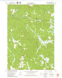 1979 Horse Creek1980 Print · USGSEau Claire County's river valleys and township borders are captured here in the late seventies, showing a landscape of working timber and gravel lands. Genealogists can locate family lands near Koehler Ford, Schoolhouse Creek, and the Hamilton Falls area.
 - 1979 Map of Lake Eau Claire East, 1980 Print
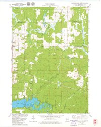 1979 Lake Eau Claire East1980 Print · USGSThe area east of Lake Eau Claire in the late seventies is a landscape of winding creeks and quiet settlements. Researchers can trace family history at Ludington Cem or locate rural landmarks like Wilson Chapel and Hamilton Falls.
 - 1979 Map of Lake Eau Claire West, 1980 Print
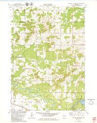 1979 Lake Eau Claire West1980 Print · USGSThe Eau Claire river valley in the late seventies was a landscape of winding creeks and quiet settlements. Researchers can trace rural landmarks like Ludington, locate the Ludington Cem, or follow the Chicago and North Western rail line.
 - 1979 Map of Simes Creek, 1980 Print
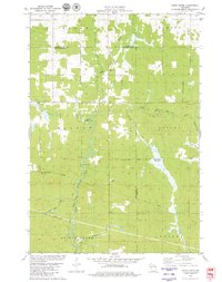 1979 Simes Creek1980 Print · USGSThe borderlands of Eau Claire, Chippewa, and Clark counties are mapped here in the late seventies. Researchers can locate specific rural landmarks such as Hamilton Falls, the Wilson Lookout Tower, and the Pleasant Valley Ch.
End of results
Showing maps 1-4 of 4
Top cities near Bridge Creek
- Seymour historical maps
- Osseo historical maps
- Augusta historical maps
- Fall Creek historical maps
- Town of Lincoln historical maps
- Edson historical maps
See more
Top neighborhoods of Bridge Creek
Frequently asked questions
- What are the different types of historical maps available for Bridge Creek?
- What is the oldest map of Bridge Creek?
- Where can I purchase historical maps of Bridge Creek for my home or office?
- Where can I download high-res historical maps of Bridge Creek?
- Are there historical topographic maps available for Bridge Creek?
- Is there historical aerial imagery available for Bridge Creek?
- Where are historical maps of Bridge Creek sourced from?