1960s Maps of Grant County, Wisconsin
Explore 21 historic maps of Grant County from the 1960s. These maps offer a rare glimpse into what life looked like during the 1960s — showing old roads, neighborhoods, homes, and landmarks that have changed or disappeared over time.
Whether you're researching your family's past, planning a metal detecting trip, or studying how Grant County's landscape evolved across the 1960s, these high-resolution maps are a powerful tool for exploring the history of this region.
- Focus on a specific era: All maps on this page are from the 1960s, giving you a focused view of this time period.
- See what’s changed: Compare century-old streets, trails, and buildings to today's modern landscape using overlays and satellite layers.
- Research with precision: Use these maps for genealogy, historical research, land use analysis, or educational projects.
- View, download, or print: Maps are fully viewable online in high resolution, and can be downloaded or printed for your own records.
Start exploring Grant County's history through authentic maps from the 1960s. This is your window into the past.
Grant County, WI maps
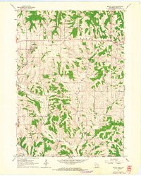
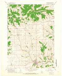
(21)- 1960 Map of Muscoda, 1962 Print
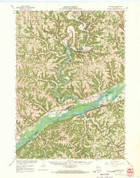
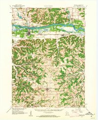 1960 Muscoda1962 Print · USGSThe Wisconsin River valley and the rugged driftless uplands are captured here in the early 1960s. Researchers can trace the path of the Chicago Milwaukee St Paul and Pacific railroad or locate rural landmarks like St John Ch and Strawberry Sch.
 - 1961 Map of Dubuque
 1961 Dubuque1961 Print · USGSThe Tri-State region's river-and-rail landscape is captured here during the early sixties, showing the convergence of Iowa, Illinois, and Wisconsin. Trace mid-century rail lines like the Chicago Great Western Ry and explore sites like the Savanna Ordnance Depot and Backbone State Park.
 - 1961 Map of La Crosse
 1961 La Crosse1961 Print · USGSThe Driftless Area at the start of the 1960s reveals a complex network of river towns and rail lines along the Mississippi River. Genealogists and historians can trace old settlements like New Amsterdam and Wyattville or locate major landmarks like Camp McCoy Military Reservation and Effigy Mounds National Monument.
 - 1961 Map of Dickeyville, 1962 Print
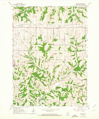
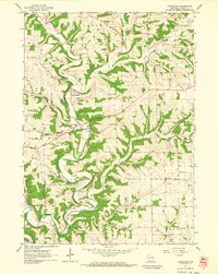
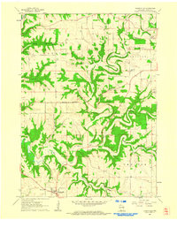 1961 Dickeyville1962 Print · USGSGrant County's rolling farmland and deep river valleys are captured here in the early sixties. Researchers can trace rural life through landmarks like the Little Grant Mine, family-named cemeteries such as Kaump Cem, and local schoolhouses like Maple Glen Sch.3 unique versions available
 - 1961 Map of Kieler, 1962 Print
 1961 Kieler1962 Print · USGSGrant County is captured in the early sixties as a region of upland farming and quiet river hollows along the state line. Researchers can trace rural landmarks from Sinsinawa Mound to the crossroads at Fair Play, Happy Corners, and the Jamestown Cem.3 unique versions available
 - 1962 Map of Dubuque
 1962 Dubuque1962 Print · USGSThe Tri-State region's river-and-rail economy is captured here in the early sixties, centered on the Mississippi River bluffs. Genealogists and historians can locate Numerous lead and zinc mines, the New Melleray Abbey Monastery, and rural hubs like Saint Olaf.2 unique versions available
 - 1962 Map of Clayton
 1962 Clayton1962 Print · USGSThe Upper Mississippi riverfront in the early sixties is defined by a dense network of islands and competing rail lines. Genealogists can locate family sites at the Norwegian Ch Cem or Clayton Cem while tracing the old river village of Clayton.3 unique versions available
 - 1962 Map of Mount Hope, 1964 Print
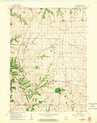
 1962 Mount Hope1964 Print · USGSThe ridgelines and river valleys of Grant County are captured here in the early sixties, showing the agricultural heart of Mount Hope and Mount Ida. Researchers can trace family history through local sites like Casler Cem, Little Grant Cem, and the Badger Sch.
 - 1962 Map of Beetown, 1964 Print
 1962 Beetown1964 Print · USGSGrant County’s Driftless Area remains a patchwork of valley farms and ridge-top roads during the early sixties. Genealogists and researchers can trace family lands near Beetown, identifying local landmarks like Flat Rock Sch, Dodge Cem, and several old Mines.2 unique versions available
 - 1962 Map of Stitzer, 1964 Print
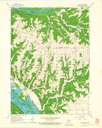
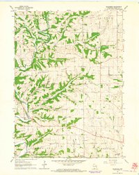
 1962 Stitzer1964 Print · USGSGrant County’s dissected uplands are shown in the early sixties as a network of farmsteads and railroad towns. Genealogists can locate family landmarks like Blue Sch and Ebenezer Cem, or trace the old rail stops at Preston and Lancaster Junction.
 - 1962 Map of Fennimore, 1964 Print
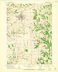
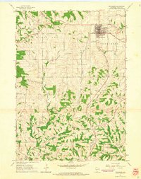 1962 Fennimore1964 Print · USGSFennimore and the surrounding Grant County ridges are shown here in the early sixties as a thriving rail and agricultural center. Genealogists can trace family landmarks like McGhan Cem, rural schools such as Rowdon Sch, and the path of the Chicago and North Western railroad.
 - 1962 Map of Bloomington, 1964 Print
 1962 Bloomington1964 Print · USGSGrant County in the early sixties remains a landscape of high ridges and winding creek valleys. Genealogists and local researchers can trace the locations of family plots at Hermitage Cem or Patch Grove Cem and follow the old routes along Military Ridge.2 unique versions available
 - 1962 Map of Bagley, 1964 Print
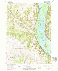
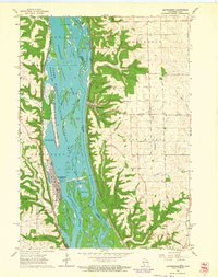
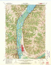
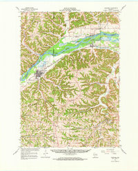
 1962 Bagley1964 Print · USGSThe confluence of the Wisconsin and Mississippi Rivers comes to life in the early sixties, showing the vital rail-and-river hub of Grant County. Genealogists can trace the rural landscape near Bagley, Brodtville, and family sites like Lumpkin Cem.
 - 1962 Map of Guttenberg, 1964 Print
 1962 Guttenberg1964 Print · USGSThe Mississippi River corridor appears in transition during the early sixties, marking the state line between Iowa and Wisconsin. Trace old rail lines, family burial sites like Scott Cem, and river navigation landmarks including Lock and Dam No 10.2 unique versions available
 - 1962 Map of Lancaster, 1964 Print
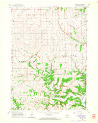
 1962 Lancaster1964 Print · USGSGrant County is captured in the early sixties as a thriving agricultural and rail hub centered on the city of Lancaster. Genealogists and historians can trace numerous rural landmarks, from the Chicago and North Western line to old schoolhouses like Cement Sch and Fairview Sch.
 - 1962 Map of Hurricane, 1964 Print
 1962 Hurricane1964 Print · USGSGrant County in the early sixties remains a landscape of deep-cut river valleys and quiet agricultural plateaus. Genealogists can trace family names through rural landmarks like Hurricane Sch, Kinney Cem, and the small settlement at Flora Fountain.2 unique versions available
 - 1962 Map of Ellenboro, 1964 Print
 1962 Ellenboro1964 Print · USGSGrant County's rural landscape is captured here in the early sixties, showing the intricate network of ridge-top farms and valley settlements. Genealogists can trace family footprints across several burial sites and rural institutions, including Whig Cem, Union Sch, and the riverside community of Ellenboro.2 unique versions available
 - 1965 Map of La Crosse
 1965 La Crosse1965 Print · USGSThe Driftless Area and the Upper Mississippi valley are captured here during a period of steady mid-century growth. Researchers can trace the rail lines of the Chicago and North Western or locate riverfront sites like Effigy Mounds National Monument and the Camp McCoy Military Reservation.
 - 1967 Map of Prairie Du Chien, 1969 Print
 1967 Prairie Du Chien1969 Print · USGSThe river-and-rail hub of the Upper Mississippi comes alive in this late-sixties study of the Wisconsin-Iowa border. Genealogists can locate family names at Campbell Cem and Hazen Corners Cem or trace old rail lines through Harpers Ferry and Marquette.
 - 1967 Map of Boscobel, 1970 Print
 1967 Boscobel1970 Print · USGSWisconsin's Driftless Area in the late sixties shows a landscape of deep hollows and river islands along the Wisconsin River. Genealogists and local historians can trace family locations near rural landmarks like St Patrick Cem, the Wayside Chapel, and the riverside settlement of Blue River.
 - 1967 Map of Wauzeka, 1970 Print
 1967 Wauzeka1970 Print · USGSCrawford and Grant Counties are captured here in the late sixties as the river valleys and ridge-top farms maintained their traditional layouts. Trace the paths of the Chicago Milwaukee St Paul and Pacific railroad through Wauzeka or locate rural landmarks like St Lawrence Ch and the Kickapoo Indian Caverns.
End of results
Showing maps 1-21 of 21
Top cities of Grant County
- Platteville historical maps
- Lancaster historical maps
- Boscobel historical maps
- Fennimore historical maps
- Jamestown historical maps
- Cuba City historical maps
See more
Frequently asked questions
- What are the different types of historical maps available for Grant County?
- What is the oldest map of Grant County?
- Where can I purchase historical maps of Grant County for my home or office?
- Where can I download high-res historical maps of Grant County?
- Are there historical topographic maps available for Grant County?
- Is there historical aerial imagery available for Grant County?
- Where are historical maps of Grant County sourced from?