1980s Maps of Iowa County, Wisconsin
Explore 11 historic maps of Iowa County from the 1980s. These maps offer a rare glimpse into what life looked like during the 1980s — showing old roads, neighborhoods, homes, and landmarks that have changed or disappeared over time.
Whether you're researching your family's past, planning a metal detecting trip, or studying how Iowa County's landscape evolved across the 1980s, these high-resolution maps are a powerful tool for exploring the history of this region.
- Focus on a specific era: All maps on this page are from the 1980s, giving you a focused view of this time period.
- See what’s changed: Compare century-old streets, trails, and buildings to today's modern landscape using overlays and satellite layers.
- Research with precision: Use these maps for genealogy, historical research, land use analysis, or educational projects.
- View, download, or print: Maps are fully viewable online in high resolution, and can be downloaded or printed for your own records.
Start exploring Iowa County's history through authentic maps from the 1980s. This is your window into the past.
Iowa County, WI maps
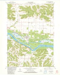
(11)- 1981 Map of Monroe
 1981 Monroe1981 Print · USGSSouthern Wisconsin and the Illinois borderlands come into focus in the early 1980s, showcasing a landscape defined by dairy farming and river valleys. Genealogists can trace family roots through historic hubs like Monroe, Stoughton, and Brodhead, or locate regional landmarks such as Yellowstone Lake and the Sugar River.
 - 1983 Map of Pleasant Ridge
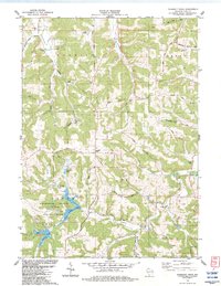 1983 Pleasant Ridge1983 Print · USGSIowa County is shown in the early eighties as a landscape of ridges and valleys transitioning into the recreation lands of the state park. Researchers can trace rural lineages through local landmarks like Rockwell Mills, Wyoming Sch, and the Griffith Cem.
 - 1983 Map of Highland West
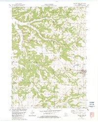 1983 Highland West1983 Print · USGSIn the driftless country of the early 1980s, the village of Highland and the Bohemian Ridge show a landscape shaped by narrow hollows and ridge-top farming. Genealogists and hikers can trace old routes like Staner Road or locate historic sites like St Johns Ch and Centerville.
 - 1983 Map of Highland East
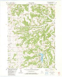 1983 Highland East1983 Print · USGSIowa County uplands and the village of Highland are documented here in the early eighties as the region balanced agriculture with recreation. Researchers can locate many rural burial grounds like St Malachy Cem or trace the drainage of Pompey Pillar Creek.
 - 1983 Map of Muscoda
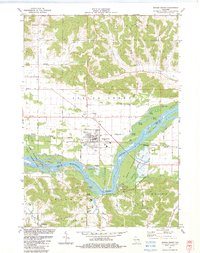
 1983 Muscoda1983 Print · USGSMuscoda and the river valley in the early eighties show a landscape of island sloughs and ridge-top farming. Trace local family roots at Pleasant Hill Cem, find rural landmarks like Eagle Corners, or follow the Fourth Principal Meridian.
 - 1983 Map of Lone Rock
 1983 Lone Rock1983 Print · USGSRichland County's riverfront and the bluffs of the Driftless Area are captured here in the early eighties. Researchers can trace the rail lines of the Chicago Milwaukee St Paul and Pacific or locate rural sites like Dixon Sch and Lone Rock Cem.
 - 1983 Map of Avoca
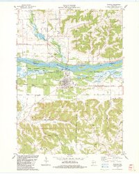
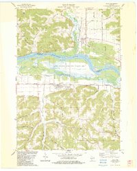 1983 Avoca1983 Print · USGSThe Wisconsin River valley comes into sharp focus during the early eighties, showing the floodplain wetlands and the high ridges above the water. Genealogists can locate family landmarks like Avoca Cem, Fairview Ch, and the winding Snake Creek.
 - 1983 Map of Spring Green
 1983 Spring Green1983 Print · USGSThe Wisconsin River valley in the early eighties shows a landscape defined by braided waterways and cultural landmarks. Genealogists can locate family sites like Old Helena Cem and Big Hollow Cem, or trace the grounds of Taliesin and Hillside Sch.
 - 1983 Map of Clyde
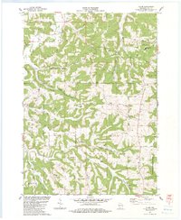 1983 Clyde1983 Print · USGSThe Driftless Area of Iowa County in the early eighties is a landscape of high ridges and deep hollows where rural life centered on valley roads and upland farms. Genealogists can locate family landmarks like St Malachy Ch, Dunbar Hill, and the secluded Norwegian Hollow.
 - 1984 Map of Dubuque North, 1985 Print
 1984 Dubuque North1985 Print · USGSThis Tri-State region was a hub of Midwestern mining and river commerce in the mid-eighties. Researchers can trace the legacy of the Lead District through specific sites like Annie Mine or locate early civic centers such as First Capitol State Park.2 unique versions available
 - 1985 Map of Richland Center, 1991 Print
 1985 Richland Center1991 Print · USGSSouthwest Wisconsin’s driftless landscape in the mid-1980s is defined by its deep river valleys and tight agricultural settlements. Researchers can trace family-named landmarks like Mickelson Ridge or find remote churches and schools near Richland Center and Dodgeville.
End of results
Showing maps 1-11 of 11
Top cities of Iowa County
- Dodgeville historical maps
- Mineral Point historical maps
- Barneveld historical maps
- Highland historical maps
- Arena historical maps
- Ridgeway historical maps
See more
Frequently asked questions
- What are the different types of historical maps available for Iowa County?
- What is the oldest map of Iowa County?
- Where can I purchase historical maps of Iowa County for my home or office?
- Where can I download high-res historical maps of Iowa County?
- Are there historical topographic maps available for Iowa County?
- Is there historical aerial imagery available for Iowa County?
- Where are historical maps of Iowa County sourced from?