1950s Maps of Dodgeville, Wisconsin
Explore 3 historic maps of Dodgeville from the 1950s. These maps offer a rare glimpse into what life looked like during the 1950s — showing old roads, neighborhoods, homes, and landmarks that have changed or disappeared over time.
Whether you're researching your family's past, planning a metal detecting trip, or studying how Dodgeville's landscape evolved across the 1950s, these high-resolution maps are a powerful tool for exploring the history of this region.
- Focus on a specific era: All maps on this page are from the 1950s, giving you a focused view of this time period.
- See what’s changed: Compare century-old streets, trails, and buildings to today's modern landscape using overlays and satellite layers.
- Research with precision: Use these maps for genealogy, historical research, land use analysis, or educational projects.
- View, download, or print: Maps are fully viewable online in high resolution, and can be downloaded or printed for your own records.
Start exploring Dodgeville's history through authentic maps from the 1950s. This is your window into the past.
Dodgeville, WI maps
(3)- 1952 Map of Dodgeville, 1954 Print
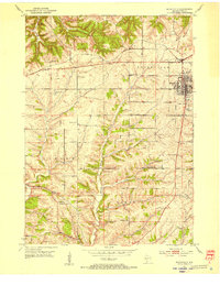 1952 Dodgeville1954 Print · USGSDodgeville and the surrounding townships in the early 1950s reveal a landscape of tight-knit rural communities connected by rail and stream. Genealogists can trace family roots through numerous local landmarks like Bethlehem Ch, Diamond Grove Sch, and St Joseph Cem.3 unique versions available
 - 1958 Map of La Crosse, 1979 Print
 1958 La Crosse1979 Print · USGSThe Driftless Area of Wisconsin and Iowa is captured here during the late seventies, showing the intricate river valleys and ridge-top settlements. Genealogists and historians can trace the rail corridors of the Soo Line or locate landmarks like Grandad Bluff and Effigy Mounds National Monument.2 unique versions available
 - 1959 Map of Dubuque, 1982 Print
 1959 Dubuque1982 Print · USGSThe Tri-State region comes alive in the mid-twentieth century as a hub of river commerce and rail transit. Genealogists and historians can trace the paths of the Illinois Central Gulf through Dubuque or locate the Savanna Ordnance Depot and Lock and Dam No 11.
End of results
Showing maps 1-3 of 3
Top cities near Dodgeville
- Dodgeville historical maps
- Mineral Point historical maps
- Spring Green historical maps
- Barneveld historical maps
- Lone Rock historical maps
- Arena historical maps
See more
Top neighborhoods of Dodgeville
Frequently asked questions
- What are the different types of historical maps available for Dodgeville?
- What is the oldest map of Dodgeville?
- Where can I purchase historical maps of Dodgeville for my home or office?
- Where can I download high-res historical maps of Dodgeville?
- Are there historical topographic maps available for Dodgeville?
- Is there historical aerial imagery available for Dodgeville?
- Where are historical maps of Dodgeville sourced from?