1950s Maps of Iron County, Wisconsin
Explore 22 historic maps of Iron County from the 1950s. These maps offer a rare glimpse into what life looked like during the 1950s — showing old roads, neighborhoods, homes, and landmarks that have changed or disappeared over time.
Whether you're researching your family's past, planning a metal detecting trip, or studying how Iron County's landscape evolved across the 1950s, these high-resolution maps are a powerful tool for exploring the history of this region.
- Focus on a specific era: All maps on this page are from the 1950s, giving you a focused view of this time period.
- See what’s changed: Compare century-old streets, trails, and buildings to today's modern landscape using overlays and satellite layers.
- Research with precision: Use these maps for genealogy, historical research, land use analysis, or educational projects.
- View, download, or print: Maps are fully viewable online in high resolution, and can be downloaded or printed for your own records.
Start exploring Iron County's history through authentic maps from the 1950s. This is your window into the past.
Iron County, WI maps
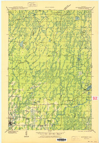
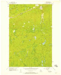
(22)- 1950 Map of Pike Lake
 1950 Pike Lake1950 Print · USGSNorthern Wisconsin's timber and lake country comes to life in the mid-century, showing a landscape shaped by conservation and seasonal recreation. Local historians can trace the locations of the Riley Creek CCC Camp, Shady Knoll Sch, and numerous family-named landmarks like Patterson Lake.
 - 1950 Map of Lac Du Flambeau
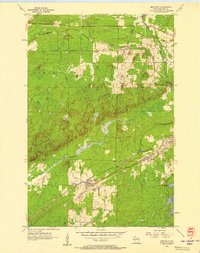
 1950 Lac Du Flambeau1950 Print · USGSThe northern lake country of Vilas and Oneida Counties is captured here at mid-century, centered on the Lac du Flambeau reservation. Researchers can trace the old Chicago and Northwestern rail line and locate landmarks like the Marlands Sch or the Flambeau Fire Tower.
 - 1950 Map of Butternut
 1950 Butternut1950 Print · USGSWisconsin's Northwoods were still defined by logging camps and rural school districts in the mid-twentieth century. Genealogists and local historians can trace the foundations of Butternut and the surrounding townships, locating sites like Agenda Town Hall, Old Camp, and Tank Sch.
 - 1951 Map of Lac Du Flambeau
 1951 Lac Du Flambeau1951 Print · USGSNorthern Wisconsin's lake country is captured here during the mid-century, showing the established communities of the Flambeau area. Genealogists and local historians can trace the Chicago and Northwestern rail line and find sites like Marlands Sch or the Flambeau Fire Tower.
 - 1953 Map of Ashland, 1964 Print
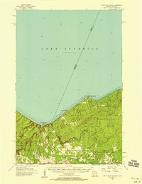
 1953 Ashland1964 Print · USGSNorthern Wisconsin's lakefront and timberlands are seen here in the mid-1950s, showing the intersection of industrial rail lines and vast wilderness. Genealogists and historians can trace the Soo Line through rail towns like Mellen or locate family roots in the Apostle Islands and Bad River Indian Reservation.3 unique versions available
 - 1953 Map of Rice Lake, 1967 Print
 1953 Rice Lake1967 Print · USGSNorthwest Wisconsin during the mid-fifties reveals a landscape defined by timber, rail, and water. Genealogists and historians can trace the development of river towns like Ladysmith and Rice Lake along the Soo Line and Chicago and North Western railroads.2 unique versions available
 - 1954 Map of Iron Mountain, 1964 Print
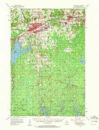
 1954 Iron Mountain1964 Print · USGSUpper Michigan and Northeastern Wisconsin are shown in detail during the mid-fifties, when the logging and mining economies still moved by rail. Trace the rail lines of the Soo Line to remote stops like Koepenick Station or explore the Iron Range near Iron Mountain.2 unique versions available
 - 1955 Map of Mercer, 1957 Print
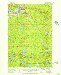
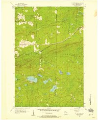
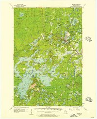 1955 Mercer1957 Print · USGSIron County in the mid-1950s is a landscape of expansive forests and interconnected waterways. Researchers can trace the path of the CHICAGO AND NORTHWESTERN railroad or locate local landmarks like Springstead Sch and Murrays Landing.4 unique versions available
 - 1955 Map of Ironwood, 1957 Print
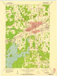 1955 Ironwood1957 Print · USGSIronwood and Hurley stand at the center of the Gogebic Range during the mid-fifties, where Michigan mining meets Wisconsin timber. Genealogists can locate family homes near Sleight Sch, trace the Cary Mine operations, or find rural landmarks like the Finnish Ch and Van Buskirk.5 unique versions available
 - 1955 Map of Winchester, 1957 Print
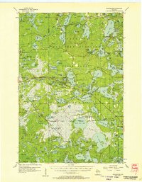 1955 Winchester1957 Print · USGSVilas County's lake country is captured here during the mid-fifties, showing the intersection of state forest lands and tribal geography. Trace the old rail lines of the Chicago and Northwestern or locate landmarks like Birch Lake Sch and the Cranberry Bogs.4 unique versions available
 - 1955 Map of Wakefield, 1957 Print
 1955 Wakefield1957 Print · USGSThe iron country of the Upper Peninsula is frozen in time during the mid-fifties, showing the industrial core of the Gogebic Range. Genealogists and historians can trace the early layout of Wakefield and its surrounding mining hubs like Ramsay and Verona before the landscape of the Sunday Lake Mine was further altered.3 unique versions available
 - 1955 Map of Ironwood, 1961 Print
 1955 Ironwood1961 Print · USGSThe Gogebic Range iron district comes to life in this mid-century study of the Michigan-Wisconsin borderlands. Trace the industrial rail networks and mines like Newport Mine alongside the Finnish Ch and vanished local schools.2 unique versions available
 - 1956 Map of Saxon, 1957 Print
 1956 Saxon1957 Print · USGSIron County's northern rail corridors and forest lands are captured here in the mid-fifties as the timber and transit industries shaped the landscape. Genealogists and researchers can trace family plots at Greenwood Cem or locate historic landmarks like the County Fairground and Upson Lookout Tower.2 unique versions available
 - 1956 Map of North Ironwood, 1957 Print
 1956 North Ironwood1957 Print · USGSThe Lake Superior shoreline and the waterfall-rich Black River define this mid-century Gogebic County landscape. Researchers can trace rural life through sites like Roosevelt Sch, the Gogebic County Airport, and the Hautala Corner crossroads.3 unique versions available
 - 1956 Map of Upson, 1957 Print
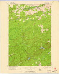
 1956 Upson1957 Print · USGSIron County's Northwoods are captured here in the mid-1950s, showing a landscape defined by timber history and rail. Researchers can trace the Soo Line through Upson and Rouse, or locate remote sites like McIver Camp.2 unique versions available
 - 1956 Map of Iron Belt, 1957 Print
 1956 Iron Belt1957 Print · USGSIron County mining towns and timberlands are captured here during the mid-fifties industrial era. Researchers can trace the rail-to-mine connections through Iron Belt, Pence, and Montreal, or locate family sites near Hillside Cem.2 unique versions available
 - 1956 Map of Little Girls Point, 1958 Print
 1956 Little Girls Point1958 Print · USGSThe Wisconsin-Michigan border along the Montreal River is captured here during the mid-fifties, showing the deep woods and dramatic coastline. Genealogists and historians can locate rural landmarks like Saxon Union Church, Lake School, and the remote landing at Saxon Harbor.2 unique versions available
 - 1956 Map of Mt. Whittlesey, 1958 Print
 1956 Mt. Whittlesey1958 Print · USGSThe Wisconsin Northwoods of the mid-1950s reveal a landscape of iron mining history and glacial lakes between Ashland and Iron counties. Genealogists and researchers can trace the old rail lines of the Soo Line, the settlement at Ballou, and the Berkshire Mine Ruins.
 - 1958 Map of Ashland
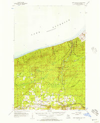
 1958 Ashland1958 Print · USGSCoastal Wisconsin and the Michigan borderlands meet here in the late fifties, dominated by the timbered expanses and iron-rich ranges. Genealogists can trace family footprints in settlements like Odanah and Montreal, or locate landmarks such as the Coast Guard Station and Agricultural Experiment Station.
 - 1958 Map of Iron River, 1968 Print
 1958 Iron River1968 Print · USGSThe Upper Peninsula in the late fifties is captured here as a landscape of timber, iron, and rail. Genealogists and historians can trace rail stops like Mass Station or explore the coastlines of Lake Gogebic and Keweenaw Bay.3 unique versions available
 - 1959 Map of Rice Lake
 1959 Rice Lake1959 Print · USGSNorthwest Wisconsin in the late fifties was a land of expanding road networks and deep-seated timber history. Genealogists and historians can trace rail lines like the Soo Line RR and Chicago St Paul Minneapolis and Omaha Ry as they link settlements from Spooner to Medford.
 - 1959 Map of Iron Mountain
 1959 Iron Mountain1959 Print · USGSThe northwoods of Wisconsin and the Michigan border are captured here in the mid-fifties, showing a landscape defined by timber, water, and rail. Researchers can trace historic junctions like Hiles Junction, the expansive Nicolet National Forest, and lakefront settlements from Rhinelander to Tomahawk.2 unique versions available
End of results
Showing maps 1-22 of 22
Top cities of Iron County
- Mercer historical maps
- Hurley historical maps
- Montreal historical maps
- Kimball historical maps
- Saxon historical maps
- Gurney historical maps
Frequently asked questions
- What are the different types of historical maps available for Iron County?
- What is the oldest map of Iron County?
- Where can I purchase historical maps of Iron County for my home or office?
- Where can I download high-res historical maps of Iron County?
- Are there historical topographic maps available for Iron County?
- Is there historical aerial imagery available for Iron County?
- Where are historical maps of Iron County sourced from?