1940s Maps of Springstead, Sherman
Explore 3 historic maps of Springstead from the 1940s. These maps offer a rare glimpse into what life looked like during the 1940s — showing old roads, neighborhoods, homes, and landmarks that have changed or disappeared over time.
Whether you're researching your family's past, planning a metal detecting trip, or studying how Springstead's landscape evolved across the 1940s, these high-resolution maps are a powerful tool for exploring the history of this region.
- Focus on a specific era: All maps on this page are from the 1940s, giving you a focused view of this time period.
- See what’s changed: Compare century-old streets, trails, and buildings to today's modern landscape using overlays and satellite layers.
- Research with precision: Use these maps for genealogy, historical research, land use analysis, or educational projects.
- View, download, or print: Maps are fully viewable online in high resolution, and can be downloaded or printed for your own records.
Start exploring Springstead's history through authentic maps from the 1940s. This is your window into the past.
Springstead, Sherman maps
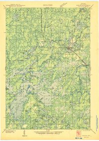
(3)- 1940 Map of Mercer, 1953 Print
 1940 Mercer1953 Print · USGSIron County’s lake-rich landscape is captured in the early 1940s, showing the early growth of Northwoods tourism and timber management. Researchers can trace the rail corridor of the Chicago and Northwestern, find the rural Springstead Sch, and locate the historic Mercer Fire Tower.
 - 1945 Map of Mercer
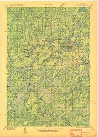
 1945 Mercer1945 Print · USGSIron County in the mid-1940s is defined by its massive flowage systems and transition from rail to highway travel. Genealogists and researchers can trace the rural infrastructure of Mercer via the Springstead Sch, Mercer Fire Tower, and the Chicago and Northwestern tracks.
 - 1947 Map of Mercer
 1947 Mercer1947 Print · USGSIron County’s lake country is captured here during the post-war years as the regional transport network evolved. Researchers can trace family roots through settlements like Mercer and Springstead, or locate landmarks such as the Springstead Sch and the Mercer Fire Tower.
End of results
Showing maps 1-3 of 3
Top cities near Springstead
- Minocqua historical maps
- Lac du Flambeau historical maps
- Mercer historical maps
- Fifield historical maps
- Manitowish Waters historical maps
- Winchester historical maps
Frequently asked questions
- What are the different types of historical maps available for Springstead?
- What is the oldest map of Springstead?
- Where can I purchase historical maps of Springstead for my home or office?
- Where can I download high-res historical maps of Springstead?
- Are there historical topographic maps available for Springstead?
- Is there historical aerial imagery available for Springstead?
- Where are historical maps of Springstead sourced from?