1950s Maps of La Crosse County, Wisconsin
Explore 5 historic maps of La Crosse County from the 1950s. These maps offer a rare glimpse into what life looked like during the 1950s — showing old roads, neighborhoods, homes, and landmarks that have changed or disappeared over time.
Whether you're researching your family's past, planning a metal detecting trip, or studying how La Crosse County's landscape evolved across the 1950s, these high-resolution maps are a powerful tool for exploring the history of this region.
- Focus on a specific era: All maps on this page are from the 1950s, giving you a focused view of this time period.
- See what’s changed: Compare century-old streets, trails, and buildings to today's modern landscape using overlays and satellite layers.
- Research with precision: Use these maps for genealogy, historical research, land use analysis, or educational projects.
- View, download, or print: Maps are fully viewable online in high resolution, and can be downloaded or printed for your own records.
Start exploring La Crosse County's history through authentic maps from the 1950s. This is your window into the past.
La Crosse County, WI maps
(5)- 1953 Map of Eau Claire, 1965 Print
 1953 Eau Claire1965 Print · USGSWest-central Wisconsin in the mid-fifties shows a landscape of river-valley industry and vast wildlife refuges during the transition from rails to modern highways. Genealogists and historians can trace the rail corridors of the Chicago and North Western or locate family-named landmarks like Decorah Mound and Chippewa Island.4 unique versions available
 - 1956 Map of Brownsville, 1958 Print
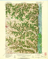 1956 Brownsville1958 Print · USGSSoutheastern Minnesota and the Mississippi River bottoms are captured here in the mid-fifties, showing the region's transition from rural school districts. Researchers can trace dozens of family-named landmarks and closed schools like Peacock Ridge Sch (Abandoned) or visit St Peters Ch.2 unique versions available
 - 1956 Map of La Crescent, 1958 Print
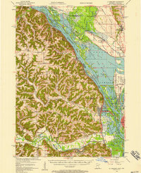 1956 La Crescent1958 Print · USGSThe Mississippi River borderlands thrive in the mid-fifties, showing the transition from the high ridges of Houston and Winona counties to the Wisconsin prairie. Genealogists can trace family names across South Ridge Ch, Loretta Sch, and cemeteries like Crucifixion Cem.2 unique versions available
 - 1958 Map of Eau Claire
 1958 Eau Claire1958 Print · USGSWestern Wisconsin in the late fifties shows a landscape of growing regional hubs and massive wildlife refuges. Trace the rail lines of the Chicago and North Western between Eau Claire and Marshfield, or explore the terrain around Iron Mound and Lake Wissota.
 - 1958 Map of La Crosse, 1979 Print
 1958 La Crosse1979 Print · USGSThe Driftless Area of Wisconsin and Iowa is captured here during the late seventies, showing the intricate river valleys and ridge-top settlements. Genealogists and historians can trace the rail corridors of the Soo Line or locate landmarks like Grandad Bluff and Effigy Mounds National Monument.2 unique versions available
End of results
Showing maps 1-5 of 5
Top cities of La Crosse County
- La Crosse historical maps
- Onalaska historical maps
- Holmen historical maps
- West Salem historical maps
- Shelby historical maps
- Bangor historical maps
See more
Frequently asked questions
- What are the different types of historical maps available for La Crosse County?
- What is the oldest map of La Crosse County?
- Where can I purchase historical maps of La Crosse County for my home or office?
- Where can I download high-res historical maps of La Crosse County?
- Are there historical topographic maps available for La Crosse County?
- Is there historical aerial imagery available for La Crosse County?
- Where are historical maps of La Crosse County sourced from?