1970s Maps of La Crosse County, Wisconsin
Explore 6 historic maps of La Crosse County from the 1970s. These maps offer a rare glimpse into what life looked like during the 1970s — showing old roads, neighborhoods, homes, and landmarks that have changed or disappeared over time.
Whether you're researching your family's past, planning a metal detecting trip, or studying how La Crosse County's landscape evolved across the 1970s, these high-resolution maps are a powerful tool for exploring the history of this region.
- Focus on a specific era: All maps on this page are from the 1970s, giving you a focused view of this time period.
- See what’s changed: Compare century-old streets, trails, and buildings to today's modern landscape using overlays and satellite layers.
- Research with precision: Use these maps for genealogy, historical research, land use analysis, or educational projects.
- View, download, or print: Maps are fully viewable online in high resolution, and can be downloaded or printed for your own records.
Start exploring La Crosse County's history through authentic maps from the 1970s. This is your window into the past.
La Crosse County, WI maps
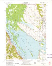
(6)- 1973 Map of Galesville, 1975 Print
 1973 Galesville1975 Print · USGSGalesville and the winding Black River corridor are captured here during the early 1970s. Researchers can trace family roots through the Decorah Prairie Cem, locate old junctions like Butman Corners, and explore the wetlands of the Van Loon State Wildlife Area.
 - 1973 Map of Pickwick, 1975 Print
 1973 Pickwick1975 Print · USGSThe Mississippi River bluffs and valleys of Winona County are captured here in the mid-1970s. Genealogists and local historians can trace family locations from Pickwick and Dakota to rural sites like Wilson Cemetery and New Hartford.2 unique versions available
 - 1973 Map of La Crescent, 1976 Print
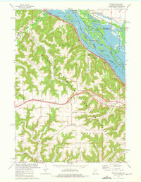
 1973 La Crescent1976 Print · USGSThe Mississippi River valley in the early seventies shows a complex landscape of island refuges and bluff-side settlements. Genealogists and historians can trace the tracks of the Chicago Milwaukee St Paul and Pacific and locate historic sites like Crucifixion Cem or Hokah.
 - 1973 Map of Holmen, 1976 Print
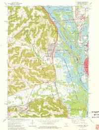
 1973 Holmen1976 Print · USGSThe Upper Mississippi riverfront and its wide prairie terraces are documented here in the early 1970s. Researchers can locate family landmarks like Oak Grove Sch and Green Mound Cem, or trace the rail lines through Midway and Dresbach.
 - 1976 Map of La Crosse
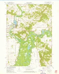
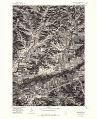
 1976 La Crosse1976 Print · USGSThe Driftless Area and Mississippi River valley are captured here in the mid-seventies, showing a landscape of deep coulees and river commerce. Genealogists can trace family footprints from La Crosse to smaller hamlets like Newburg Corners and Witoka.
 - 1976 Map of Sparta NW, 1978 Print
 1976 Sparta NW1978 Print · USGSThe river valley between Bangor and Rockland is captured here during the mid-seventies, showing a landscape defined by contour farming and rail lines. You can trace the winding path of the La Crosse River and several tributaries including Burns Creek.2 unique versions available
End of results
Showing maps 1-6 of 6
Top cities of La Crosse County
- La Crosse historical maps
- Onalaska historical maps
- Holmen historical maps
- West Salem historical maps
- Shelby historical maps
- Bangor historical maps
See more
Frequently asked questions
- What are the different types of historical maps available for La Crosse County?
- What is the oldest map of La Crosse County?
- Where can I purchase historical maps of La Crosse County for my home or office?
- Where can I download high-res historical maps of La Crosse County?
- Are there historical topographic maps available for La Crosse County?
- Is there historical aerial imagery available for La Crosse County?
- Where are historical maps of La Crosse County sourced from?