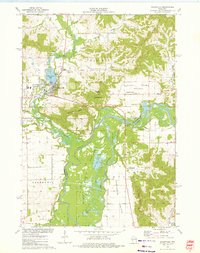
1973 Map of Galesville
USGS Topo · Published 1975About this map
Galesville sits at the northern edge of this Wisconsin survey, where the Beaver Creek valley transitions into the broad alluvial plains of the Black River. The settlement is defined by its industry and recreation, featuring the C & NW railroad line, a local Fairground, and the shoreline of Marinuka Lake. To the south, the landscape opens into the Van Loon State Wildlife Area, a sprawling network of wetlands and backwaters including Van Loon Lake and Goose Lake nestled within the Black River bottomlands. The geography is punctuated by prominent bluffs and mounds, such as Decorah Peak and Queen Bluff, which rise sharply above the river valley. Local history is preserved in the location of the Decorah Prairie Cem and the Berean Ch, while the agricultural character of the era is evident in the sprawling Decorah Prairie and Amsterdam Prairie settlements.
Find a feature on this map
46 named features on this map. Tap any name to fly to it.
Don’t see what you’re looking for? This feature index may not catch every label — zoom into the map to look around manually.
Map Details
Editions of this 1973 Galesville Map
This is the sole edition of this map. No revisions or reprints were ever made.
Other maps of this area

1926 · North Bend
USGS Topo · 1:62,500

1927 · La Crosse
USGS Topo · 1:62,500

1929 · Galesville
USGS Topo · 1:62,500

1929 · North Bend
USGS Topo · 1:62,500

1930 · La Crescent
USGS Topo · 1:62,500

1930 · La Crosse
USGS Topo · 1:62,500

1953 · Eau Claire
USGS Topo · 1:250,000

1956 · La Crescent
USGS Topo · 1:62,500

1958 · Eau Claire
USGS Topo · 1:250,000

1958 · La Crosse
USGS Topo · 1:250,000