
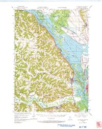
1956 Map of La Crescent
USGS Topo · Published 1958About this map
Mississippi River backwaters and the high bluffs of the Driftless Area define this mid-1950s survey of the border region between Minnesota and Wisconsin. The river's complex geography is represented through numerous side channels like Hammond Chute and Dresbach Slough, which weave through the Upper Mississippi River Wildlife and Fish Refuge. On the Minnesota side, a network of steep valleys and ridges hosts a rural landscape of neighborhood schools such as Whitlock Sch and Pleasant View Sch.
Find a feature on this map
132 named features on this map. Tap any name to fly to it.
Don’t see what you’re looking for? This feature index may not catch every label — zoom into the map to look around manually.
Map Details
Editions of this 1956 La Crescent Map
2 editions found
Other maps of this area

1926 · Stoddard
USGS Topo · 1:62,500

1926 · North Bend
USGS Topo · 1:62,500

1927 · La Crosse
USGS Topo · 1:62,500

1929 · Fountain City
USGS Topo · 1:62,500

1929 · Galesville
USGS Topo · 1:62,500

1929 · North Bend
USGS Topo · 1:62,500

1930 · La Crescent
USGS Topo · 1:62,500

1930 · La Crosse
USGS Topo · 1:62,500

1934 · Winona
USGS Topo · 1:62,500

1937 · Winona
USGS Topo · 1:62,500