
1926 Map of Stoddard
USGS Topo · Published 1926About this map
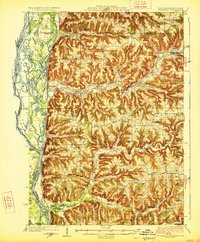
The Mississippi River creates a complex landscape of islands and side channels in this 1920s survey, where the Chicago Burlington and Quincy RR hugs the shoreline. Moving inland from the riverbank, the terrain rises sharply into the distinctive coulees and ridges of Vernon and La Crosse Counties. The map reveals a high density of rural schoolhouses such as Evening Star School, White Pigeon School, and Brinkman Ridge School serving the farming families of Hamburg and Bergen townships. Small settlements like Romance and Chaseburg are centered along the winding course of Coon Creek and the Bad Axe River, reflecting an era of localized rural commerce before modern highway expansion. The presence of Warner Landing and numerous sloughs like Mormon Slough and Goose Slough highlights the river's ongoing role in regional navigation and geography.
Find a feature on this map
87 named features on this map. Tap any name to fly to it.
Don’t see what you’re looking for? This feature index may not catch every label — zoom into the map to look around manually.
Map Details
Editions of this 1926 Stoddard Map
2 editions found
Other maps of this area

1903 · Waukon
USGS Topo · 1:125,000

1909 · Sparta
USGS Topo · 1:62,500

1923 · Viroqua
USGS Topo · 1:62,500

1924 · Gays Mills
USGS Topo · 1:62,500

1926 · Gays Mills
USGS Topo · 1:62,500

1926 · Viroqua
USGS Topo · 1:62,500

1927 · La Crosse
USGS Topo · 1:62,500

1929 · Ferryville
USGS Topo · 1:62,500

1930 · La Crescent
USGS Topo · 1:62,500

1930 · La Crosse
USGS Topo · 1:62,500