
1926 Map of Gays Mills
USGS Topo · Published 1926About this map
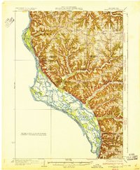
The Kickapoo River winds deeply through the heart of the Driftless Area in the mid-1920s, anchoring a landscape defined by narrow valleys and prominent ridgelines. The river valley serves as the primary corridor for commerce, where the Chicago Milwaukee and St Paul RR connects riverside settlements like Soldiers Grove, Readstown, and Gays Mills. Away from the water, the upland plateaus are divided by family-named landmarks such as Swiggum Ridge, Mickelson Ridge, and Gunderson Ridge, reflecting the Norwegian and European immigrant heritage of the region's farming community.
Find a feature on this map
105 named features on this map. Tap any name to fly to it.
Don’t see what you’re looking for? This feature index may not catch every label — zoom into the map to look around manually.
Map Details
Editions of this 1926 Gays Mills Map
This is the sole edition of this map. No revisions or reprints were ever made.
Other maps of this area

1903 · Waukon
USGS Topo · 1:125,000

1923 · Viroqua
USGS Topo · 1:62,500

1924 · Gays Mills
USGS Topo · 1:62,500

1926 · Stoddard
USGS Topo · 1:62,500

1926 · Viroqua
USGS Topo · 1:62,500

1926 · La Farge
USGS Topo · 1:62,500

1926 · Wauzeka
USGS Topo · 1:62,500

1929 · Ferryville
USGS Topo · 1:62,500

1929 · Prairie Du Chien
USGS Topo · 1:62,500
1932 · Ferryville
USGS Topo · 1:62,500