
1924 Map of Gays Mills
USGS Topo · Published 1957About this map
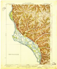
Gays Mills and the winding Kickapoo River corridor anchor this mid-1920s survey of the driftless region's deeply etched landscape. The area is defined by a dense network of high ridges, such as Helgerson Ridge, Mickelson Ridge, and Howe Ridge, which dictated the placement of early settlements and travel routes. Small agricultural communities and rural schoolhouses are peppered throughout the uplands, including the Rising Sun School and the Gardner School. The Chicago Milwaukee and St Paul railroad traces the river valley, connecting the trading hubs of Soldiers Grove and Readstown. Local genealogy is well-served by the inclusion of numerous country churches like Southwest Prairie Church and the large Evergreen Cemetery near Mt Sterling. Distinctive landmarks like Monument Rock serve as navigational anchors amidst the intricate system of hollows and branch creeks that feed the Kickapoo watershed.
Find a feature on this map
95 named features on this map. Tap any name to fly to it.
Don’t see what you’re looking for? This feature index may not catch every label — zoom into the map to look around manually.
Map Details
Editions of this 1924 Gays Mills Map
This is the sole edition of this map. No revisions or reprints were ever made.
Other maps of this area

1903 · Waukon
USGS Topo · 1:125,000

1923 · Viroqua
USGS Topo · 1:62,500

1926 · Gays Mills
USGS Topo · 1:62,500

1926 · Stoddard
USGS Topo · 1:62,500

1926 · Viroqua
USGS Topo · 1:62,500

1926 · La Farge
USGS Topo · 1:62,500

1926 · Wauzeka
USGS Topo · 1:62,500

1929 · Ferryville
USGS Topo · 1:62,500

1929 · Prairie Du Chien
USGS Topo · 1:62,500
1932 · Ferryville
USGS Topo · 1:62,500