1960s Maps of Bevent, Wisconsin
Explore 3 historic maps of Bevent from the 1960s. These maps offer a rare glimpse into what life looked like during the 1960s — showing old roads, neighborhoods, homes, and landmarks that have changed or disappeared over time.
Whether you're researching your family's past, planning a metal detecting trip, or studying how Bevent's landscape evolved across the 1960s, these high-resolution maps are a powerful tool for exploring the history of this region.
- Focus on a specific era: All maps on this page are from the 1960s, giving you a focused view of this time period.
- See what’s changed: Compare century-old streets, trails, and buildings to today's modern landscape using overlays and satellite layers.
- Research with precision: Use these maps for genealogy, historical research, land use analysis, or educational projects.
- View, download, or print: Maps are fully viewable online in high resolution, and can be downloaded or printed for your own records.
Start exploring Bevent's history through authentic maps from the 1960s. This is your window into the past.
Bevent, WI maps
(3)- 1964 Map of Hatley, 1966 Print
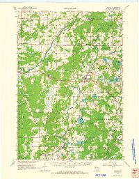 1964 Hatley1966 Print · USGSMarathon County in the mid-1960s reveals a rural landscape defined by the Chicago and North Western Railroad and glacial lake clusters. Researchers can locate family landmarks like Forestville Cem, Easton Sch, and the Elderon Lookout Tower.
 - 1969 Map of Rosholt, 1972 Print
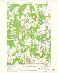 1969 Rosholt1972 Print · USGSCentral Wisconsin's glaciated landscape is shown here in the late sixties, capturing the rural communities and lake-rich terrain of Portage County. Genealogists can trace family footprints near Rosholt, the Old Railroad Grade, and the small settlement of Galloway.2 unique versions available
 - 1969 Map of Rosholt NW, 1972 Print
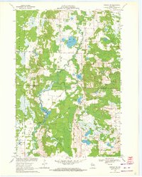 1969 Rosholt NW1972 Print · USGSThe Marathon and Portage county line bisects this rural Wisconsin landscape during the late sixties, a region defined by its glacial lakes and river bends. Trace local roots around Shantytown or explore the waterways of Big Bass Lake and Bentley Pond.2 unique versions available
End of results
Showing maps 1-3 of 3
Top cities near Bevent
- Wausau historical maps
- Stevens Point historical maps
- Weston historical maps
- Kronenwetter historical maps
- Rib Mountain historical maps
- Rothschild historical maps
See more
Top neighborhoods of Bevent
Frequently asked questions
- What are the different types of historical maps available for Bevent?
- What is the oldest map of Bevent?
- Where can I purchase historical maps of Bevent for my home or office?
- Where can I download high-res historical maps of Bevent?
- Are there historical topographic maps available for Bevent?
- Is there historical aerial imagery available for Bevent?
- Where are historical maps of Bevent sourced from?