1970s Maps of Rib Falls, Wisconsin
Explore 2 historic maps of Rib Falls from the 1970s. These maps offer a rare glimpse into what life looked like during the 1970s — showing old roads, neighborhoods, homes, and landmarks that have changed or disappeared over time.
Whether you're researching your family's past, planning a metal detecting trip, or studying how Rib Falls's landscape evolved across the 1970s, these high-resolution maps are a powerful tool for exploring the history of this region.
- Focus on a specific era: All maps on this page are from the 1970s, giving you a focused view of this time period.
- See what’s changed: Compare century-old streets, trails, and buildings to today's modern landscape using overlays and satellite layers.
- Research with precision: Use these maps for genealogy, historical research, land use analysis, or educational projects.
- View, download, or print: Maps are fully viewable online in high resolution, and can be downloaded or printed for your own records.
Start exploring Rib Falls's history through authentic maps from the 1970s. This is your window into the past.
Rib Falls, WI maps
(2)- 1978 Map of Hamburg, 1979 Print
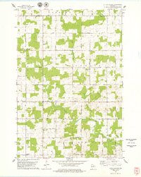
 1978 Hamburg1979 Print · USGSMarathon County in the late seventies is a landscape of river confluences and quiet rural crossroads. Genealogists and local historians can locate early family landmarks like St Pauls Cem, the Hamburg PO, and Salem Ch along the banks of the Rib River.
 - 1978 Map of Little Chicago, 1979 Print
 1978 Little Chicago1979 Print · USGSMarathon County in the late seventies is captured here as a patchwork of active dairy farms and small townships. Researchers can trace family roots through numerous sites like Maple Grove Sch, Big Hill Cem, and the rural community of Naugart.2 unique versions available
End of results
Showing maps 1-2 of 2
Top cities near Rib Falls
- Wausau historical maps
- Merrill historical maps
- Kronenwetter historical maps
- Rib Mountain historical maps
- Mosinee historical maps
- Maine historical maps
See more
Frequently asked questions
- What are the different types of historical maps available for Rib Falls?
- What is the oldest map of Rib Falls?
- Where can I purchase historical maps of Rib Falls for my home or office?
- Where can I download high-res historical maps of Rib Falls?
- Are there historical topographic maps available for Rib Falls?
- Is there historical aerial imagery available for Rib Falls?
- Where are historical maps of Rib Falls sourced from?