2000s (21st Century) Maps of Rib Falls, Wisconsin
Explore 4 historic maps of Rib Falls from the 2000s (21st Century). These maps offer a rare glimpse into what life looked like during the 2000s — showing old roads, neighborhoods, homes, and landmarks that have changed or disappeared over time.
Whether you're researching your family's past, planning a metal detecting trip, or studying how Rib Falls's landscape evolved across the 2000s, these high-resolution maps are a powerful tool for exploring the history of this region.
- Focus on a specific era: All maps on this page are from the 2000s, giving you a focused view of this time period.
- See what’s changed: Compare century-old streets, trails, and buildings to today's modern landscape using overlays and satellite layers.
- Research with precision: Use these maps for genealogy, historical research, land use analysis, or educational projects.
- View, download, or print: Maps are fully viewable online in high resolution, and can be downloaded or printed for your own records.
Start exploring Rib Falls's history through authentic maps from the 2000s. This is your window into the past.
Rib Falls, WI maps
(4)- 2022 Map of Marathon, 2022 Print
 2022 Marathon2022 Print · USGSMarathon County is captured here in the early 2020s, centered on the community of Marathon City along the Big Rib River. Genealogists and local historians can locate specific sites like Saint Mary's Catholic Cem and Saint Matthews Lutheran Cem amidst the network of rural roads.
 - 2022 Map of Hamburg, 2022 Print
 2022 Hamburg2022 Print · USGSMarathon County in the early twenty-first century remains a landscape of river valleys and agricultural grids. Genealogists can locate family burial sites at Saint Johns Lutheran Cem or Lueck Cem and trace the waters of the Big Rib River.
 - 2022 Map of Edgar, 2022 Print
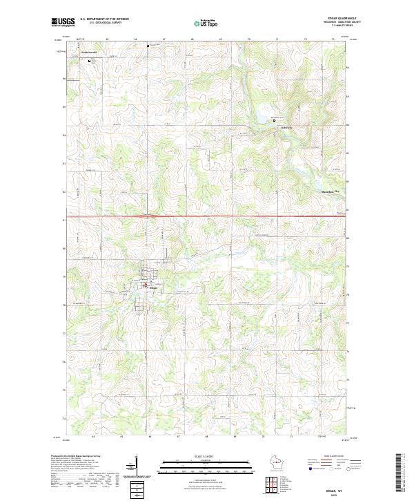 2022 Edgar2022 Print · USGSMarathon County’s rural townships are captured in this recent survey of the central Wisconsin dairy and timber heartland. Genealogists and local historians can locate several family cemeteries, including Tessmer Cem and Baesemann Cem, alongside the village of Edgar.
 - 2022 Map of Little Chicago, 2022 Print
 2022 Little Chicago2022 Print · USGSMarathon County is shown in detail here during the 2020s, revealing a landscape of winding river forks and rural crossroads. You can trace local family history through several burial sites like Friedenshain Cem and Zion Cem near the settlement of Naugart.
End of results
Showing maps 1-4 of 4
Top cities near Rib Falls
- Wausau historical maps
- Merrill historical maps
- Kronenwetter historical maps
- Rib Mountain historical maps
- Mosinee historical maps
- Maine historical maps
See more
Frequently asked questions
- What are the different types of historical maps available for Rib Falls?
- What is the oldest map of Rib Falls?
- Where can I purchase historical maps of Rib Falls for my home or office?
- Where can I download high-res historical maps of Rib Falls?
- Are there historical topographic maps available for Rib Falls?
- Is there historical aerial imagery available for Rib Falls?
- Where are historical maps of Rib Falls sourced from?