1980s Maps of Ringle, Wisconsin
Explore 5 historic maps of Ringle from the 1980s. These maps offer a rare glimpse into what life looked like during the 1980s — showing old roads, neighborhoods, homes, and landmarks that have changed or disappeared over time.
Whether you're researching your family's past, planning a metal detecting trip, or studying how Ringle's landscape evolved across the 1980s, these high-resolution maps are a powerful tool for exploring the history of this region.
- Focus on a specific era: All maps on this page are from the 1980s, giving you a focused view of this time period.
- See what’s changed: Compare century-old streets, trails, and buildings to today's modern landscape using overlays and satellite layers.
- Research with precision: Use these maps for genealogy, historical research, land use analysis, or educational projects.
- View, download, or print: Maps are fully viewable online in high resolution, and can be downloaded or printed for your own records.
Start exploring Ringle's history through authentic maps from the 1980s. This is your window into the past.
Ringle, WI maps
(5)- 1982 Map of Bevent
 1982 Bevent1982 Print · USGSEastern Marathon County at the start of the eighties shows a landscape of glacial lakes and quiet river valleys. Genealogists can locate family landmarks like Our Saviors Cem or trace rural life near Bevent and St Ladislaus Sch.
 - 1982 Map of Hatley
 1982 Hatley1982 Print · USGSThe village of Hatley and the community of Norrie are shown here in the early eighties as the railroad still influenced the local layout. Researchers can trace family history at St Florian Sch Cem or explore the shores of Go-To-It Lake and the Plover River.
 - 1982 Map of Ringle
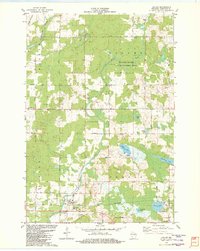
 1982 Ringle1982 Print · USGSMarathon County in the early eighties shows a landscape of river-valley industry and quiet crossroads communities. You can trace the Chicago and North Western line through Ringle or locate local landmarks like Easton Sch and the Forestville Cem.
 - 1982 Map of Mission Lake, 1983 Print
 1982 Mission Lake1983 Print · USGSMarathon County’s lake country is captured here in the early 1980s, showing a landscape of glacial eskers and timbered wetlands. Researchers can trace family names on roads like Konkel Road or locate the Evergreen Rest Cem and Elderon Lookout Tower.
 - 1984 Map of Wausau, 1990 Print
 1984 Wausau1990 Print · USGSMarathon and Portage counties come into focus during the mid-eighties as industrial river towns and sprawling conservation areas define the Central Wisconsin landscape. Researchers can trace the rail corridors of the Soo Line or locate rural landmarks like Rib Mountain State Park and St Marys Cem.
End of results
Showing maps 1-5 of 5
Top cities near Ringle
- Wausau historical maps
- Weston historical maps
- Kronenwetter historical maps
- Rib Mountain historical maps
- Rothschild historical maps
- Mosinee historical maps
See more
Frequently asked questions
- What are the different types of historical maps available for Ringle?
- What is the oldest map of Ringle?
- Where can I purchase historical maps of Ringle for my home or office?
- Where can I download high-res historical maps of Ringle?
- Are there historical topographic maps available for Ringle?
- Is there historical aerial imagery available for Ringle?
- Where are historical maps of Ringle sourced from?