1900-1909 Maps of East Allis, West Allis
Explore 6 historic maps of East Allis from 1900-1909. These maps offer a rare glimpse into what life looked like during the 1900s — showing old roads, neighborhoods, homes, and landmarks that have changed or disappeared over time.
Whether you're researching your family's past, planning a metal detecting trip, or studying how East Allis's landscape evolved across the 1900s, these high-resolution maps are a powerful tool for exploring the history of this region.
- Focus on a specific era: All maps on this page are from the 1900s, giving you a focused view of this time period.
- See what’s changed: Compare century-old streets, trails, and buildings to today's modern landscape using overlays and satellite layers.
- Research with precision: Use these maps for genealogy, historical research, land use analysis, or educational projects.
- View, download, or print: Maps are fully viewable online in high resolution, and can be downloaded or printed for your own records.
Start exploring East Allis's history through authentic maps from the 1900s. This is your window into the past.
East Allis, West Allis maps
(6)- 1901 Map of Milwaukee
 1901 Milwaukee1901 Print · USGSThe Milwaukee lakefront and surrounding townships are shown here as a burgeoning industrial and rail corridor at the start of the 1900s. Trace early property and rail development at Whitefish Bay, Wauwatosa, and the defunct Dillman Sta. depot.
 - 1901 Map of Waukesha
 1901 Waukesha1901 Print · USGSSoutheastern Wisconsin at the turn of the century shows a landscape transitioning from rural townships to a complex rail-linked corridor. Genealogists and historians can trace the exact locations of early communities like Freistadt, Fussville, and Brookfield P.O. along the Menomonee River.
 - 1901 Map of Bayview
 1901 Bayview1901 Print · USGSThe Lake Michigan shoreline south of Milwaukee comes alive in the late Victorian era as industry and rail lines expand. Trace early coastal growth in Cudahy and South Milwaukee, or locate old interior settlements like New Coeln, Kilbournville, and Lamberton P.O..4 unique versions available
 - 1901 Map of Muskego
 1901 Muskego1901 Print · USGSSoutheastern Wisconsin at the close of the nineteenth century was a landscape of budding dairy hubs and interconnected glacial lakes. Researchers can trace early rural life across these townships, finding legacy sites like Union Church, the path of the Wisconsin Central Railroad, and original footprints for Tess Corners and Big Bend.4 unique versions available
 - 1906 Map of Waukesha
 1906 Waukesha1906 Print · USGSWaukesha and the Milwaukee outskirts thrive at the turn of the century during a height of rail connectivity. Genealogists can trace family footprints in early settlements like Freistadt, Lannon, and the neighborhoods of Wauwatosa.4 unique versions available
 - 1906 Map of Milwaukee
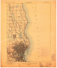 1906 Milwaukee1906 Print · USGSThe Milwaukee lakefront and its surrounding townships show the height of early twentieth-century rail and river development. Researchers can trace ancestral property near National Home or locate vanished stops along the Lake Shore Line and Chicago Milwaukee and St Paul RR.4 unique versions available
End of results
Showing maps 1-6 of 6
Frequently asked questions
- What are the different types of historical maps available for East Allis?
- What is the oldest map of East Allis?
- Where can I purchase historical maps of East Allis for my home or office?
- Where can I download high-res historical maps of East Allis?
- Are there historical topographic maps available for East Allis?
- Is there historical aerial imagery available for East Allis?
- Where are historical maps of East Allis sourced from?