1990s Maps of Arrowhead Park, Grand Chute
Explore 3 historic maps of Arrowhead Park from the 1990s. These maps offer a rare glimpse into what life looked like during the 1990s — showing old roads, neighborhoods, homes, and landmarks that have changed or disappeared over time.
Whether you're researching your family's past, planning a metal detecting trip, or studying how Arrowhead Park's landscape evolved across the 1990s, these high-resolution maps are a powerful tool for exploring the history of this region.
- Focus on a specific era: All maps on this page are from the 1990s, giving you a focused view of this time period.
- See what’s changed: Compare century-old streets, trails, and buildings to today's modern landscape using overlays and satellite layers.
- Research with precision: Use these maps for genealogy, historical research, land use analysis, or educational projects.
- View, download, or print: Maps are fully viewable online in high resolution, and can be downloaded or printed for your own records.
Start exploring Arrowhead Park's history through authentic maps from the 1990s. This is your window into the past.
Arrowhead Park, Grand Chute maps
(3)- 1992 Map of Neenah, 1996 Print
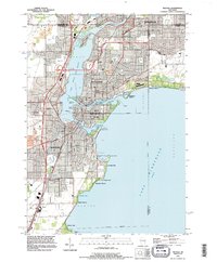 1992 Neenah1996 Print · USGSThe Fox River Valley saw significant development in the early nineties, centered on the growing industrial and residential districts of Neenah and Menasha. Genealogists and local historians can trace family locations through numerous sites like St Patricks Cem, Stroebe Island, and the rail corridors of the Soo Line.
 - 1992 Map of Greenville, 1996 Print
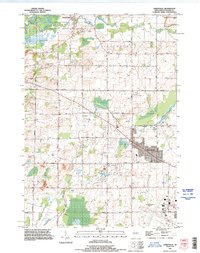 1992 Greenville1996 Print · USGSThe Outagamie County countryside near Greenville is shown here in the 1990s as suburban expansion begins to meet established dairy and river lands. Researchers can locate family plots at Wanderers Rest Cemetery and trace the early footprint of the Outagamie County Airport.
 - 1992 Map of Appleton, 1996 Print
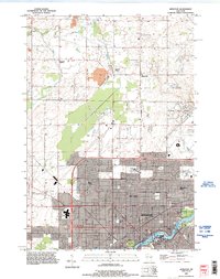 1992 Appleton1996 Print · USGSThe Fox River valley saw significant suburban and commercial expansion in the 1990s as the urban core pushed north. Genealogists and researchers can trace local landmarks like Lawrence College, Riverside Cem, and the rural crossroads of Mackville.
End of results
Showing maps 1-3 of 3
Frequently asked questions
- What are the different types of historical maps available for Arrowhead Park?
- What is the oldest map of Arrowhead Park?
- Where can I purchase historical maps of Arrowhead Park for my home or office?
- Where can I download high-res historical maps of Arrowhead Park?
- Are there historical topographic maps available for Arrowhead Park?
- Is there historical aerial imagery available for Arrowhead Park?
- Where are historical maps of Arrowhead Park sourced from?