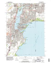
1992 Map of Neenah
USGS Topo · Published 1996About this map
Lake Winnebago and the Fox River dominate this industrial and residential corridor during a period of significant suburban expansion. The twin cities of Neenah and Menasha are shown in high detail, linked by Doty Island and the Menasha Channel. For genealogists, the map is particularly rich with early burial sites including St Patricks Cem, Oak Hill Cem, and St Johns Cem. The presence of the Menasha Lock and the Soo Line railroad tracks highlights the area's legacy as a water and rail hub. To the south, the settlement of Snells and the Valley Airways Airport sit near the transition to the rural township of Vinland, while the shoreline is dotted with named points like Payne Point and Wheeler Point.
Find a feature on this map
56 named features on this map. Tap any name to fly to it.
Don’t see what you’re looking for? This feature index may not catch every label — zoom into the map to look around manually.
Map Details
Editions of this 1992 Neenah Map
This is the sole edition of this map. No revisions or reprints were ever made.
Other maps of this area

1911 · Neenah
USGS Topo · 1:62,500

1955 · Neenah
USGS Topo · 1:62,500

1955 · Appleton
USGS Topo · 1:24,000

1955 · Appleton
USGS Topo · 1:62,500

1955 · Neenah
USGS Topo · 1:24,000

1955 · Green Bay
USGS Topo · 1:250,000

1956 · New London
USGS Topo · 1:48,000

1961 · Oshkosh
USGS Topo · 1:24,000

1961 · Oshkosh
USGS Topo · 1:62,500

1961 · Oshkosh NE
USGS Topo · 1:24,000