1980s Maps of Ozaukee County, Wisconsin
Explore 4 historic maps of Ozaukee County from the 1980s. These maps offer a rare glimpse into what life looked like during the 1980s — showing old roads, neighborhoods, homes, and landmarks that have changed or disappeared over time.
Whether you're researching your family's past, planning a metal detecting trip, or studying how Ozaukee County's landscape evolved across the 1980s, these high-resolution maps are a powerful tool for exploring the history of this region.
- Focus on a specific era: All maps on this page are from the 1980s, giving you a focused view of this time period.
- See what’s changed: Compare century-old streets, trails, and buildings to today's modern landscape using overlays and satellite layers.
- Research with precision: Use these maps for genealogy, historical research, land use analysis, or educational projects.
- View, download, or print: Maps are fully viewable online in high resolution, and can be downloaded or printed for your own records.
Start exploring Ozaukee County's history through authentic maps from the 1980s. This is your window into the past.
Ozaukee County, WI maps
(4)- 1980 Map of Fond Du Lac
 1980 Fond Du Lac1980 Print · USGSThe Fox River Valley and Horicon Marsh meet here during the late twentieth century, showing a transition from lakeside industry to glacial conservation. Genealogists can locate family sites at Estabrook Cem or trace the rail lines through Ripon and Waupun.
 - 1980 Map of Milwaukee, 1981 Print
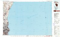 1980 Milwaukee1981 Print · USGSThe Lake Michigan shoreline and Milwaukee's urban sprawl are captured here at the start of the 1980s. Local researchers can trace family landmarks like Graceland Cemetery, educational sites like Milwaukee-Downer College, and the northern rail lines of the Chicago and North Western.
 - 1984 Map of Oconomowoc, 1985 Print
 1984 Oconomowoc1985 Print · USGSSoutheast Wisconsin in the mid-eighties shows a landscape defined by its glacial heritage and expanding metropolitan corridors. Genealogists and historians can trace the development of lakeside communities like Oconomowoc and Pewaukee, or find established settlements such as Watertown and Beaver Dam.
 - 1989 Map of Sheboygan, 1990 Print
 1989 Sheboygan1990 Print · USGSCoastal Wisconsin thrived in the late eighties as the industrial corridor between Sheboygan and Belgium expanded along the lake. Genealogists and local researchers can trace old township lines and small settlements like Howards Grove, Hingham, and Gibbsville.
End of results
Showing maps 1-4 of 4
Top cities of Ozaukee County
- Mequon historical maps
- Grafton historical maps
- Cedarburg historical maps
- Port Washington historical maps
- Saukville historical maps
- Thiensville historical maps
See more
Frequently asked questions
- What are the different types of historical maps available for Ozaukee County?
- What is the oldest map of Ozaukee County?
- Where can I purchase historical maps of Ozaukee County for my home or office?
- Where can I download high-res historical maps of Ozaukee County?
- Are there historical topographic maps available for Ozaukee County?
- Is there historical aerial imagery available for Ozaukee County?
- Where are historical maps of Ozaukee County sourced from?