1970s Maps of Osceola, Wisconsin
Explore 9 historic maps of Osceola from the 1970s. These maps offer a rare glimpse into what life looked like during the 1970s — showing old roads, neighborhoods, homes, and landmarks that have changed or disappeared over time.
Whether you're researching your family's past, planning a metal detecting trip, or studying how Osceola's landscape evolved across the 1970s, these high-resolution maps are a powerful tool for exploring the history of this region.
- Focus on a specific era: All maps on this page are from the 1970s, giving you a focused view of this time period.
- See what’s changed: Compare century-old streets, trails, and buildings to today's modern landscape using overlays and satellite layers.
- Research with precision: Use these maps for genealogy, historical research, land use analysis, or educational projects.
- View, download, or print: Maps are fully viewable online in high resolution, and can be downloaded or printed for your own records.
Start exploring Osceola's history through authentic maps from the 1970s. This is your window into the past.
Osceola, WI maps
(9)- 1974 Map of St. Croix Dalles SW, 1976 Print
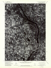
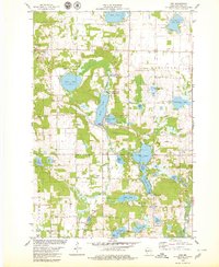
 1974 St. Croix Dalles SW1976 Print · USGSPolk County farmland and riverfront settlements appear in high-altitude detail during the mid-1970s. Trace the historical footprints of Osceola and Dresser to see how these communities and their surrounding fields were organized decades ago.
 - 1974 Map of St. Croix Dalles SE, 1976 Print
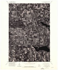
 1974 St. Croix Dalles SE1976 Print · USGSAgricultural land and glacial lakes define this pocket of Polk County during the mid-seventies. Researchers can examine the detailed field patterns and natural drainage systems surrounding the Apple River on this overhead survey.
 - 1974 Map of St. Croix Dalles NE, 1976 Print
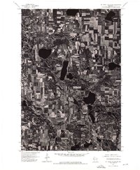
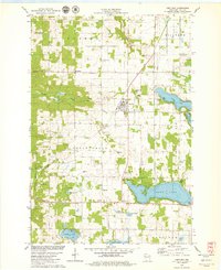
 1974 St. Croix Dalles NE1976 Print · USGSPolk County, Wisconsin, is captured in this mid-seventies aerial survey, showing a landscape of productive dairy farms and deep northern lakes. Local researchers can trace the detailed layout of Centuria and the surrounding township road network during this era.
 - 1974 Map of St Croix Dalles NW, 1976 Print
 1974 St Croix Dalles NW1976 Print · USGSThe river valley between Minnesota and Wisconsin is captured during the mid-1970s, showing a landscape defined by agriculture and woodland. Trace the early development of St Croix Falls and Taylors Falls along the banks of the St Croix River.
 - 1975 Map of Stillwater
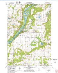
 1975 Stillwater1975 Print · USGSThe Twin Cities and the St. Croix Valley are captured in the mid-seventies, showing the urban growth of Minneapolis and St Paul. Researchers can trace old rail corridors of the Northern Pacific RR and locate tribal lands at the Mille Lacs Indian Reservation.2 unique versions available
 - 1978 Map of Centuria, 1979 Print
 1978 Centuria1979 Print · USGSPolk County at the end of the 1970s shows a landscape of small rural settlements and scattered family burial grounds. Genealogists can trace local roots at Fristad Cem and St John Cem while exploring the rail corridor of the Soo Line.
 - 1978 Map of Osceola, 1979 Print
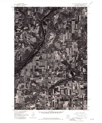
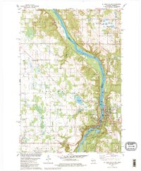
 1978 Osceola1979 Print · USGSThe St. Croix River valley in the late seventies reveals a landscape of riverside villages and conservation lands. Genealogists can locate Ramsey Cem and Pleasant Prairie Cem, while rail enthusiasts can trace the Soo Line through Dresser.3 unique versions available
 - 1978 Map of St. Croix Dalles, 1979 Print
 1978 St. Croix Dalles1979 Print · USGSThe river gorge at the Minnesota-Wisconsin border was well-established as a recreational and industrial hub by the late 1970s. Local researchers can trace family sites near Kahbakong Cem, find the Chisago Lakes Sch, or follow the Old Railroad Grade through Shafer.2 unique versions available
 - 1978 Map of Nye, 1979 Print
 1978 Nye1979 Print · USGSPolk County in the late seventies is a landscape of glacial lakes and quiet rail stops like Nye. Genealogists and historians can locate old rural landmarks like West Immanuel Ch, Sand Lake Cem, and the tracks of the Soo Line.
End of results
Showing maps 1-9 of 9
Top cities near Osceola
- New Richmond historical maps
- Lindström historical maps
- Somerset historical maps
- Town of Star Prairie historical maps
- Osceola historical maps
- Town of Alden historical maps
See more
Top neighborhoods of Osceola
Frequently asked questions
- What are the different types of historical maps available for Osceola?
- What is the oldest map of Osceola?
- Where can I purchase historical maps of Osceola for my home or office?
- Where can I download high-res historical maps of Osceola?
- Are there historical topographic maps available for Osceola?
- Is there historical aerial imagery available for Osceola?
- Where are historical maps of Osceola sourced from?