1970s Maps of Knox, Wisconsin
Explore 4 historic maps of Knox from the 1970s. These maps offer a rare glimpse into what life looked like during the 1970s — showing old roads, neighborhoods, homes, and landmarks that have changed or disappeared over time.
Whether you're researching your family's past, planning a metal detecting trip, or studying how Knox's landscape evolved across the 1970s, these high-resolution maps are a powerful tool for exploring the history of this region.
- Focus on a specific era: All maps on this page are from the 1970s, giving you a focused view of this time period.
- See what’s changed: Compare century-old streets, trails, and buildings to today's modern landscape using overlays and satellite layers.
- Research with precision: Use these maps for genealogy, historical research, land use analysis, or educational projects.
- View, download, or print: Maps are fully viewable online in high resolution, and can be downloaded or printed for your own records.
Start exploring Knox's history through authentic maps from the 1970s. This is your window into the past.
Knox, WI maps
(4)- 1979 Map of Timms Hill, 1980 Print
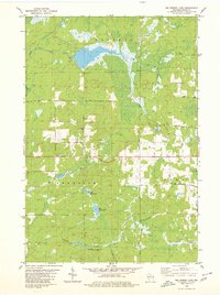
 1979 Timms Hill1980 Print · USGSThe Wisconsin Northwoods are captured here in the late seventies, centered on the state's highest elevation. Local historians can locate the Garden of Memory Church, trace old routes like Goetzke Road, and explore the shoreline of Spirit Lake.2 unique versions available
 - 1979 Map of Spirit, 1980 Print
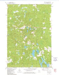
 1979 Spirit1980 Print · USGSThe township of Spirit and its surrounding rural countryside are captured in the late seventies as a community of small farms and timberlands. Local historians can trace old homestead access via Settlement Road, visit the Hillcrest Cem, and locate the Old Railroad Grade near Squaw Creek.2 unique versions available
 - 1979 Map of Big Briens Lake, 1980 Print
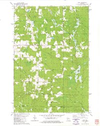
 1979 Big Briens Lake1980 Print · USGSThe rural borderlands of Price County come into focus during the late seventies, showing the township lines of Hackett, Prentice, and Knox. Researchers can trace old family lands along Nyberg Hill Road or follow the waters of the South Fork Jump River.2 unique versions available
 - 1979 Map of Brantwood, 1980 Print
 1979 Brantwood1980 Print · USGSThe Northwoods landscape near the Price and Oneida county lines is captured here in the late seventies, centered on the Soo Line rail corridor. Genealogists and local historians can trace old homesteads and community sites like the Finnish Cem, Tripoli Sch, and the settlement of Brantwood.
End of results
Showing maps 1-4 of 4
Top cities near Knox
- Minocqua historical maps
- Worcester historical maps
- Ogema historical maps
- Rib Lake historical maps
- Westboro historical maps
- Prentice historical maps
See more
Top neighborhoods of Knox
Frequently asked questions
- What are the different types of historical maps available for Knox?
- What is the oldest map of Knox?
- Where can I purchase historical maps of Knox for my home or office?
- Where can I download high-res historical maps of Knox?
- Are there historical topographic maps available for Knox?
- Is there historical aerial imagery available for Knox?
- Where are historical maps of Knox sourced from?