1960s Maps of Saint Croix County, Wisconsin
Explore 5 historic maps of Saint Croix County from the 1960s. These maps offer a rare glimpse into what life looked like during the 1960s — showing old roads, neighborhoods, homes, and landmarks that have changed or disappeared over time.
Whether you're researching your family's past, planning a metal detecting trip, or studying how Saint Croix County's landscape evolved across the 1960s, these high-resolution maps are a powerful tool for exploring the history of this region.
- Focus on a specific era: All maps on this page are from the 1960s, giving you a focused view of this time period.
- See what’s changed: Compare century-old streets, trails, and buildings to today's modern landscape using overlays and satellite layers.
- Research with precision: Use these maps for genealogy, historical research, land use analysis, or educational projects.
- View, download, or print: Maps are fully viewable online in high resolution, and can be downloaded or printed for your own records.
Start exploring Saint Croix County's history through authentic maps from the 1960s. This is your window into the past.
Saint Croix County, WI maps
(5)- 1965 Map of Stillwater
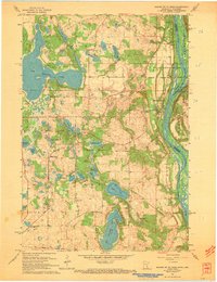
 1965 Stillwater1965 Print · USGSThe Twin Cities and the St. Croix Valley are mapped here during a period of significant post-war growth and industrial transit. Genealogists and historians can trace rail lines like the Northern Pacific RR through towns such as Rush City, Amery, and Balsam Lake.
 - 1967 Map of Marine on St Croix, 1969 Print
 1967 Marine on St Croix1969 Print · USGSAlong the St. Croix River valley in the late sixties, this area shows a landscape defined by glacial lakes and river bluffs. Trace local roots through Marine on St Croix, the Elim Cem, or the early boundaries of William O'Brien State Park.3 unique versions available
 - 1967 Map of Stillwater, 1969 Print
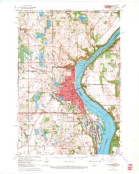 1967 Stillwater1969 Print · USGSStillwater and the St. Croix riverfront are captured here in the late sixties during a period of steady suburban expansion. Researchers can trace historic family plots at Fairview Cemetery, follow the Northern Pacific tracks, or locate the Minnesota State Prison.5 unique versions available
 - 1967 Map of Prescott, 1969 Print
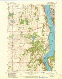
 1967 Prescott1969 Print · USGSThe confluence of the Mississippi and St. Croix Rivers is captured here in the late sixties, highlighting the border towns of Prescott and Point Douglas. Researchers can trace genealogical landmarks like Evergreen Cemetery and family-named features like Starks Mound.4 unique versions available
 - 1967 Map of Hudson, 1969 Print
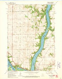
 1967 Hudson1969 Print · USGSThe riverfront communities along the border of Minnesota and Wisconsin come to life in this survey from the late sixties. Genealogists and local historians can locate early landmarks like Bissels Mounds, Mount Prairie Cem, and the Lake Elmo Airport.4 unique versions available
End of results
Showing maps 1-5 of 5
Top cities of Saint Croix County
- Hudson historical maps
- New Richmond historical maps
- Baldwin historical maps
- North Hudson historical maps
- Somerset historical maps
- Roberts historical maps
See more
Frequently asked questions
- What are the different types of historical maps available for Saint Croix County?
- What is the oldest map of Saint Croix County?
- Where can I purchase historical maps of Saint Croix County for my home or office?
- Where can I download high-res historical maps of Saint Croix County?
- Are there historical topographic maps available for Saint Croix County?
- Is there historical aerial imagery available for Saint Croix County?
- Where are historical maps of Saint Croix County sourced from?